Bondo geodata
Bondo (Bas-Uele) is a populated place; located in Democratic Republic of the Congo in Africa/Lubumbashi (GMT+2) time zone. With population of 17,860 people, there are 65 cities with bigger population in this country. Compared to other cities in Democratic Republic of the Congo, 97.1% of cities are located further ↓South; 55.7% of cities are located further ←West and 51.4% of cities have lower elevation than Bondo. Note1


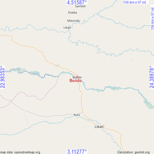
Bondo GPS coordinates[2]
3° 48' 52.596" North, 23° 41' 11.94" East
| Map corner | latitude | longitude |
|---|---|---|
| Upper-left | 4.51587°, | 22.98353° |
| Center: | 3.81461°, | 23.68665° |
| Lower-right: | 3.11277°, | 24.38978° |
| Map W x H: | 156×156 km | = 96.9×96.9mi |
| max Lat: | 4.279° ⇑2.9% North |
| Bondo: | 3.81461° |
| min Lat: | ⇓97.1% South -11.76097° |
| min Long | Bondo | max Long |
| 12.37148° | 23.68665° | 30.25224° |
| W 55.7%⇐ | ⇒44.3% E |
Elevation
Elevation of Bondo is 494 m = 1621 ft, and this is 162 m = 531 ft below average elevation for this country.
| Max E: |
1996 m = 6549 ft | 48.6% |
| Avg. | 656 m = 2152 ft | |
| Bondo | 494 m = 1621 ft | |
Min E: |
11 m = 36 ft | 51.4% |
See also: Democratic Republic of the Congo elevation on elevation.city.
Geographical zone
Bondo is located in North Torrid zone (between Equator and Tropic of Cancer). Distance of Equator is 424.1 km =263.5 mi to South.| Distance of | km | miles | from Bondo |
|---|---|---|---|
| North Pole | 9582.9 | 5954.5 | to North |
| Arctic Circle | 6977 | 4335.3 | to North |
| Tropic Cancer | 2181.8 | 1355.7 | to North |
| Equator | 424.1 | 263.5 | to South |


Nearby cities:
12 places around Bondo: (largest is in red/bold)
• Aketi
120.1 km =74.6 mi,  174°
174°
• Basoko
286.5 km =178 mi,  181°
181°
• Bongandanga
387.5 km =240.8 mi,  228°
228°
• Bosobolo
423.9 km =263.4 mi,  275°
275°
• Bumba
225.9 km =140.4 mi,  216°
216°
• Businga
315.3 km =195.9 mi,  260°
260°
• Buta
162.8 km =101.2 mi,  134°
134°
• Gbadolite
302.1 km =187.7 mi, 279°
• Gemena
438.8 km =272.7 mi, 261°
• Kisangani
403.1 km =250.5 mi,  155°
155°
• Lisala
303.7 km =188.7 mi, 232°
• Yangambi
349 km =216.9 mi, 166°
Sources, notices
• [Note1] Compared only with cities in Democratic Republic of the Congo existing in our database
• [Src1] Map data: © OpenStreetMap contributors (CC-BY-SA)
• [Src2] Other city data from geonames.org with taken over terms of usage.
• [Src3] Geographical zone / Annual Mean Temperature by Robert A. Rohde @ Wikipedia
