Bukavu geodata
Bukavu (South Kivu) is a seat of a first-order administrative division; located in Democratic Republic of the Congo in Africa/Lubumbashi (GMT+2) time zone. With population of 225,389 people, there are 10 cities with bigger population in this country. Compared to other cities in Democratic Republic of the Congo, 61.4% of cities are located further ↓South; 88.6% of cities are located further ←West and 97.1% of cities have lower elevation than Bukavu. Note1


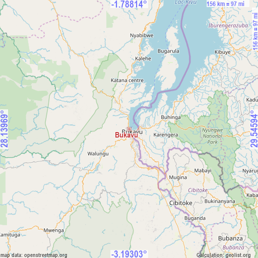
Bukavu GPS coordinates[2]
2° 29' 26.772" South, 28° 50' 34.116" East
| Map corner | latitude | longitude |
|---|---|---|
| Upper-left | -1.78814°, | 28.13969° |
| Center: | -2.49077°, | 28.84281° |
| Lower-right: | -3.19303°, | 29.54594° |
| Map W x H: | 156.2×156.2 km | = 97.1×97.1mi |
| max Lat: | 4.279° ⇑38.6% North |
| Bukavu: | -2.49077° |
| min Lat: | ⇓61.4% South -11.76097° |
| min Long | Bukavu | max Long |
| 12.37148° | 28.84281° | 30.25224° |
| W 88.6%⇐ | ⇒11.4% E |
Elevation
Elevation of Bukavu is 1631 m = 5351 ft, and this is 975 m = 3199 ft above average elevation for this country.
| Max E: |
1996 m = 6549 ft | 2.9% |
| Bukavu | 1631 m 5351 ft | |
| Avg. | 656 m = 2152 ft | |
Min E: |
11 m = 36 ft | 97.1% |
See also: Bukavu elevation on elevation.city.
Geographical zone
Bukavu is located in South Torrid zone (between Equator and Tropic of Capricorn). Distance of Equator is 276.9 km =172.1 mi to North.| Distance of | km | miles | from Bukavu |
|---|---|---|---|
| Equator | 276.9 | 172.1 | to North |
| Tropic Capricorn | 2329 | 1447.2 | to South |
| Antarctic Circle | 7124.2 | 4426.8 | to South |
| South Pole | 9730.1 | 6046 | to South |


Nearby cities:
11 places around Bukavu: (largest is in red/bold)
• Beni
338.9 km =210.6 mi,  11°
11°
• Butembo
296.9 km =184.5 mi, 9°
• Goma
100.4 km =62.4 mi,  25°
25°
• Kabare
5.8 km =3.6 mi,  263°
263°
• Kalemie
386.3 km =240 mi,  174°
174°
• Kampene
271.1 km =168.5 mi,  243°
243°
• Kasongo
323.6 km =201.1 mi,  228°
228°
• Kindu
328.2 km =203.9 mi, 261°
• Kongolo
381.2 km =236.9 mi,  212°
212°
• Sake
104.4 km =64.9 mi, 12°
• Uvira
105.8 km =65.7 mi,  161°
161°
Sources, notices
• [Note1] Compared only with cities in Democratic Republic of the Congo existing in our database
• [Src1] Map data: © OpenStreetMap contributors (CC-BY-SA)
• [Src2] Other city data from geonames.org with taken over terms of usage.
• [Src3] Geographical zone / Annual Mean Temperature by Robert A. Rohde @ Wikipedia
