Breitenbach geodata
Breitenbach (Solothurn) is a populated place; located in Switzerland in Europe/Zurich (GMT+2) time zone. With population of 3,241 people, there are 543 cities with bigger population in this country. Compared to other cities in Switzerland, 75% of cities are located further ↓South; 73.9% of cities are located further →East and 90.1% of cities have higher elevation than Breitenbach. Note1


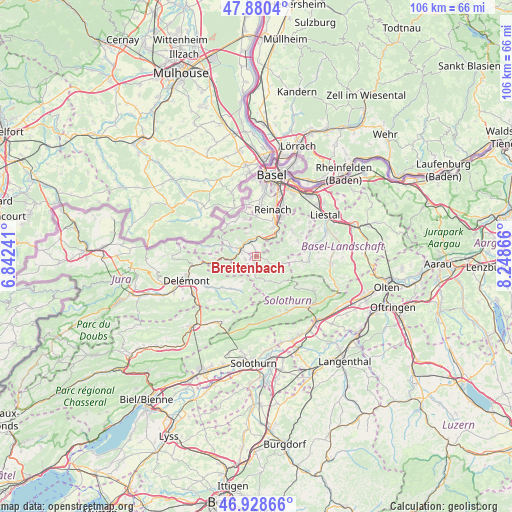
Breitenbach GPS coordinates[2]
47° 24' 24.048" North, 7° 32' 43.944" East
| Map corner | latitude | longitude |
|---|---|---|
| Upper-left | 47.8804°, | 6.84241° |
| Center: | 47.40668°, | 7.54554° |
| Lower-right: | 46.92866°, | 8.24866° |
| Map W x H: | 105.8×105.8 km | = 65.7×65.7mi |
| max Lat: | 47.76737° ⇑25% North |
| Breitenbach: | 47.40668° |
| min Lat: | ⇓75% South 45.83203° |
| min Long | Breitenbach | max Long |
| 5.97153° | 7.54554° | 10.44624° |
| W 26.1%⇐ | ⇒73.9% E |
Elevation
Elevation of Breitenbach is 394 m = 1293 ft, and this is 164.2 m = 539 ft below average elevation for this country.
| Max E: |
1845 m = 6053 ft | 90.1% |
| Avg. | 558.2 m = 1831 ft | |
| Breitenbach | 394 m = 1293 ft | |
Min E: |
197 m = 646 ft | 9.9% |
See also: Switzerland elevation on elevation.city.
Geographical zone
Breitenbach is located in North temperate zone (between Tropic of Cancer and the Arctic Circle). Distance of this North polar circle is 2130 km =1323.5 mi to North.| Distance of | km | miles | from Breitenbach |
|---|---|---|---|
| North Pole | 4735.9 | 2942.8 | to North |
| Arctic Circle | 2130 | 1323.5 | to North |
| Tropic Cancer | 2665.2 | 1656.1 | to South |
| Equator | 5271.1 | 3275.3 | to South |


Nearby cities:
15 places around Breitenbach: (largest is in red/bold)
• Blauen
5.2 km =3.2 mi,  337°
337°
• Brislach
1.2 km =0.7 mi,  352°
352°
• Bärschwil
6.1 km =3.8 mi,  243°
243°
• Büsserach
1.4 km =0.9 mi,  193°
193°
• Erschwil
3.6 km =2.2 mi, 185°
• Grellingen
5.1 km =3.2 mi,  39°
39°
• Himmelried
4.4 km =2.7 mi,  68°
68°
• Laufen
3.9 km =2.4 mi,  296°
296°
• Mervelier
7.8 km =4.8 mi,  206°
206°
• Nunningen
5.7 km =3.5 mi,  104°
104°
• Pfeffingen
6.8 km =4.2 mi,  29°
29°
• Röschenz
5.3 km =3.3 mi,  291°
291°
• Wahlen
2.3 km =1.4 mi,  257°
257°
• Zullwil
4.5 km =2.8 mi,  112°
112°
• Zwingen
3.7 km =2.3 mi, 341°
Sources, notices
• [Note1] Compared only with cities in Switzerland existing in our database
• [Src1] Map data: © OpenStreetMap contributors (CC-BY-SA)
• [Src2] Other city data from geonames.org with taken over terms of usage.
• [Src3] Geographical zone / Annual Mean Temperature by Robert A. Rohde @ Wikipedia
