Seeberg geodata
Seeberg (Bern) is a populated place; located in Switzerland in Europe/Zurich (GMT+2) time zone. With population of 1,321 people, there are 1123 cities with bigger population in this country. Compared to other cities in Switzerland, 55.8% of cities are located further ↑North; 69.2% of cities are located further →East and 53.5% of cities have lower elevation than Seeberg. Note1


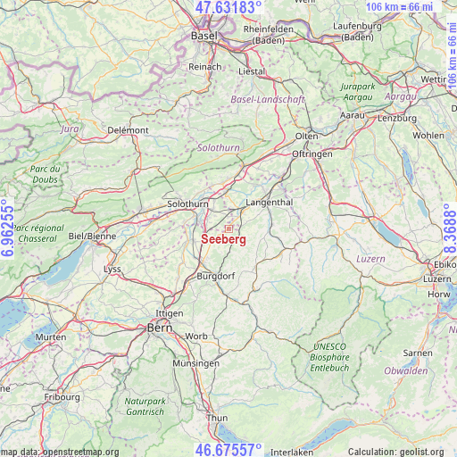
Seeberg GPS coordinates[2]
47° 9' 21.06" North, 7° 39' 56.412" East
| Map corner | latitude | longitude |
|---|---|---|
| Upper-left | 47.63183°, | 6.96255° |
| Center: | 47.15585°, | 7.66567° |
| Lower-right: | 46.67557°, | 8.3688° |
| Map W x H: | 106.3×106.3 km | = 66.1×66.1mi |
| max Lat: | 47.76737° ⇑55.8% North |
| Seeberg: | 47.15585° |
| min Lat: | ⇓44.2% South 45.83203° |
| min Long | Seeberg | max Long |
| 5.97153° | 7.66567° | 10.44624° |
| W 30.8%⇐ | ⇒69.2% E |
Elevation
Elevation of Seeberg is 489 m = 1604 ft, and this is 69.2 m = 227 ft below average elevation for this country.
| Max E: |
1845 m = 6053 ft | 46.5% |
| Avg. | 558.2 m = 1831 ft | |
| Seeberg | 489 m = 1604 ft | |
Min E: |
197 m = 646 ft | 53.5% |
See also: Switzerland elevation on elevation.city.
Geographical zone
Seeberg is located in North temperate zone (between Tropic of Cancer and the Arctic Circle). Distance of this North polar circle is 2157.9 km =1340.9 mi to North.| Distance of | km | miles | from Seeberg |
|---|---|---|---|
| North Pole | 4763.8 | 2960.1 | to North |
| Arctic Circle | 2157.9 | 1340.9 | to North |
| Tropic Cancer | 2637.3 | 1638.7 | to South |
| Equator | 5243.2 | 3258 | to South |


Nearby cities:
15 places around Seeberg: (largest is in red/bold)
• Alchenstorf
4.1 km =2.5 mi,  213°
213°
• Biberist
8.3 km =5.2 mi,  289°
289°
• Deitingen
7.5 km =4.7 mi,  331°
331°
• Derendingen
7.5 km =4.7 mi,  309°
309°
• Ersigen
8.7 km =5.4 mi,  217°
217°
• Gerlafingen
7.2 km =4.5 mi,  283°
283°
• Herzogenbuchsee
4.7 km =2.9 mi,  40°
40°
• Koppigen
5.3 km =3.3 mi,  239°
239°
• Kriegstetten
5.5 km =3.4 mi, 292°
• Oberönz
3.3 km =2.1 mi, 41°
• Ochlenberg
5.4 km =3.4 mi,  97°
97°
• Subingen
5.9 km =3.7 mi,  323°
323°
• Ursenbach
8.3 km =5.2 mi, 104°
• Wangen an der Aare
8.5 km =5.3 mi,  353°
353°
• Wynigen
5.6 km =3.5 mi,  179°
179°
Sources, notices
• [Note1] Compared only with cities in Switzerland existing in our database
• [Src1] Map data: © OpenStreetMap contributors (CC-BY-SA)
• [Src2] Other city data from geonames.org with taken over terms of usage.
• [Src3] Geographical zone / Annual Mean Temperature by Robert A. Rohde @ Wikipedia
