Koppigen geodata
Koppigen (Bern) is a populated place; located in Switzerland in Europe/Zurich (GMT+2) time zone. With population of 1,977 people, there are 844 cities with bigger population in this country. Compared to other cities in Switzerland, 57.4% of cities are located further ↑North; 71.5% of cities are located further →East and 51.5% of cities have lower elevation than Koppigen. Note1


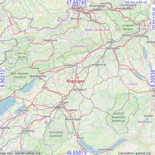
Koppigen GPS coordinates[2]
47° 7' 52.5" North, 7° 36' 18.9" East
| Map corner | latitude | longitude |
|---|---|---|
| Upper-left | 47.60745°, | 6.90213° |
| Center: | 47.13125°, | 7.60525° |
| Lower-right: | 46.65075°, | 8.30838° |
| Map W x H: | 106.4×106.4 km | = 66.1×66.1mi |
| max Lat: | 47.76737° ⇑57.4% North |
| Koppigen: | 47.13125° |
| min Lat: | ⇓42.6% South 45.83203° |
| min Long | Koppigen | max Long |
| 5.97153° | 7.60525° | 10.44624° |
| W 28.5%⇐ | ⇒71.5% E |
Elevation
Elevation of Koppigen is 482 m = 1581 ft, and this is 76.2 m = 250 ft below average elevation for this country.
| Max E: |
1845 m = 6053 ft | 48.5% |
| Avg. | 558.2 m = 1831 ft | |
| Koppigen | 482 m = 1581 ft | |
Min E: |
197 m = 646 ft | 51.5% |
See also: Switzerland elevation on elevation.city.
Geographical zone
Koppigen is located in North temperate zone (between Tropic of Cancer and the Arctic Circle). Distance of this North polar circle is 2160.7 km =1342.6 mi to North.| Distance of | km | miles | from Koppigen |
|---|---|---|---|
| North Pole | 4766.6 | 2961.8 | to North |
| Arctic Circle | 2160.7 | 1342.6 | to North |
| Tropic Cancer | 2634.6 | 1637.1 | to South |
| Equator | 5240.5 | 3256.3 | to South |


Nearby cities:
15 places around Koppigen: (largest is in red/bold)
• Alchenstorf
2.4 km =1.5 mi,  106°
106°
• Biberist
6.3 km =3.9 mi,  329°
329°
• Burgdorf
8.2 km =5.1 mi,  167°
167°
• Bätterkinden
5.1 km =3.2 mi,  270°
270°
• Derendingen
7.6 km =4.7 mi,  350°
350°
• Ersigen
4.2 km =2.6 mi,  190°
190°
• Fraubrunnen
7.7 km =4.8 mi,  229°
229°
• Gerlafingen
5.1 km =3.2 mi, 330°
• Kirchberg
5.4 km =3.4 mi,  198°
198°
• Kriegstetten
4.8 km =3 mi, 353°
• Lyssach
7.6 km =4.7 mi, 193°
• Seeberg
5.3 km =3.3 mi,  59°
59°
• Subingen
7.6 km =4.7 mi,  8°
8°
• Utzenstorf
3.9 km =2.4 mi, 272°
• Wynigen
5.4 km =3.4 mi,  121°
121°
Sources, notices
• [Note1] Compared only with cities in Switzerland existing in our database
• [Src1] Map data: © OpenStreetMap contributors (CC-BY-SA)
• [Src2] Other city data from geonames.org with taken over terms of usage.
• [Src3] Geographical zone / Annual Mean Temperature by Robert A. Rohde @ Wikipedia
