Fulenbach geodata
Fulenbach (Solothurn) is a populated place; located in Switzerland in Europe/Zurich (GMT+2) time zone. With population of 1,526 people, there are 1020 cities with bigger population in this country. Compared to other cities in Switzerland, 54.4% of cities are located further ↓South; 64.7% of cities are located further →East and 86.6% of cities have higher elevation than Fulenbach. Note1


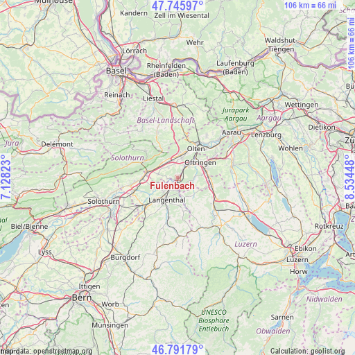
Fulenbach GPS coordinates[2]
47° 16' 15.708" North, 7° 49' 52.896" East
| Map corner | latitude | longitude |
|---|---|---|
| Upper-left | 47.74597°, | 7.12823° |
| Center: | 47.27103°, | 7.83136° |
| Lower-right: | 46.79179°, | 8.53448° |
| Map W x H: | 106.1×106.1 km | = 65.9×65.9mi |
| max Lat: | 47.76737° ⇑45.6% North |
| Fulenbach: | 47.27103° |
| min Lat: | ⇓54.4% South 45.83203° |
| min Long | Fulenbach | max Long |
| 5.97153° | 7.83136° | 10.44624° |
| W 35.3%⇐ | ⇒64.7% E |
Elevation
Elevation of Fulenbach is 406 m = 1332 ft, and this is 152.2 m = 499 ft below average elevation for this country.
| Max E: |
1845 m = 6053 ft | 86.6% |
| Avg. | 558.2 m = 1831 ft | |
| Fulenbach | 406 m = 1332 ft | |
Min E: |
197 m = 646 ft | 13.4% |
See also: Switzerland elevation on elevation.city.
Geographical zone
Fulenbach is located in North temperate zone (between Tropic of Cancer and the Arctic Circle). Distance of this North polar circle is 2145.1 km =1332.9 mi to North.| Distance of | km | miles | from Fulenbach |
|---|---|---|---|
| North Pole | 4751 | 2952.1 | to North |
| Arctic Circle | 2145.1 | 1332.9 | to North |
| Tropic Cancer | 2650.1 | 1646.7 | to South |
| Equator | 5256 | 3265.9 | to South |


Nearby cities:
15 places around Fulenbach: (largest is in red/bold)
• Aarwangen
6 km =3.7 mi,  232°
232°
• Egerkingen
6.5 km =4 mi,  326°
326°
• Gunzgen
4.8 km =3 mi,  359°
359°
• Hägendorf
7.1 km =4.4 mi,  6°
6°
• Langenthal
6.7 km =4.2 mi,  203°
203°
• Murgenthal
0.6 km =0.4 mi,  85°
85°
• Niederbuchsiten
5.3 km =3.3 mi,  302°
302°
• Oberbuchsiten
6.7 km =4.2 mi,  314°
314°
• Pfaffnau
6.9 km =4.3 mi,  134°
134°
• Roggwil
3.4 km =2.1 mi,  192°
192°
• Rothrist
5.9 km =3.7 mi,  50°
50°
• Strengelbach
7.4 km =4.6 mi,  82°
82°
• Vordemwald
5.3 km =3.3 mi, 84°
• Wolfwil
2.6 km =1.6 mi,  264°
264°
• Wynau
2.1 km =1.3 mi,  213°
213°
Sources, notices
• [Note1] Compared only with cities in Switzerland existing in our database
• [Src1] Map data: © OpenStreetMap contributors (CC-BY-SA)
• [Src2] Other city data from geonames.org with taken over terms of usage.
• [Src3] Geographical zone / Annual Mean Temperature by Robert A. Rohde @ Wikipedia
