Murgenthal geodata
Murgenthal (Aargau) is a populated place; located in Switzerland in Europe/Zurich (GMT+2) time zone. With population of 3,044 people, there are 582 cities with bigger population in this country. Compared to other cities in Switzerland, 54.5% of cities are located further ↓South; 64.4% of cities are located further →East and 85.3% of cities have higher elevation than Murgenthal. Note1


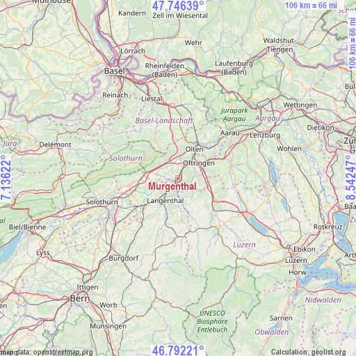
Murgenthal GPS coordinates[2]
47° 16' 17.22" North, 7° 50' 21.66" East
| Map corner | latitude | longitude |
|---|---|---|
| Upper-left | 47.74639°, | 7.13622° |
| Center: | 47.27145°, | 7.83935° |
| Lower-right: | 46.79221°, | 8.54247° |
| Map W x H: | 106.1×106.1 km | = 65.9×65.9mi |
| max Lat: | 47.76737° ⇑45.5% North |
| Murgenthal: | 47.27145° |
| min Lat: | ⇓54.5% South 45.83203° |
| min Long | Murgenthal | max Long |
| 5.97153° | 7.83935° | 10.44624° |
| W 35.6%⇐ | ⇒64.4% E |
Elevation
Elevation of Murgenthal is 409 m = 1342 ft, and this is 149.2 m = 490 ft below average elevation for this country.
| Max E: |
1845 m = 6053 ft | 85.3% |
| Avg. | 558.2 m = 1831 ft | |
| Murgenthal | 409 m = 1342 ft | |
Min E: |
197 m = 646 ft | 14.7% |
See also: Switzerland elevation on elevation.city.
Geographical zone
Murgenthal is located in North temperate zone (between Tropic of Cancer and the Arctic Circle). Distance of this North polar circle is 2145.1 km =1332.9 mi to North.| Distance of | km | miles | from Murgenthal |
|---|---|---|---|
| North Pole | 4751 | 2952.1 | to North |
| Arctic Circle | 2145.1 | 1332.9 | to North |
| Tropic Cancer | 2650.2 | 1646.8 | to South |
| Equator | 5256.1 | 3266 | to South |


Nearby cities:
15 places around Murgenthal: (largest is in red/bold)
• Aarburg
7.1 km =4.4 mi,  39°
39°
• Aarwangen
6.5 km =4 mi,  235°
235°
• Egerkingen
6.8 km =4.2 mi,  322°
322°
• Fulenbach
0.6 km =0.4 mi,  265°
265°
• Gunzgen
4.7 km =2.9 mi,  352°
352°
• Hägendorf
7.1 km =4.4 mi,  1°
1°
• Langenthal
7.1 km =4.4 mi,  207°
207°
• Niederbuchsiten
5.8 km =3.6 mi,  298°
298°
• Pfaffnau
6.5 km =4 mi,  138°
138°
• Roggwil
3.6 km =2.2 mi,  201°
201°
• Rothrist
5.5 km =3.4 mi,  46°
46°
• Strengelbach
6.8 km =4.2 mi,  82°
82°
• Vordemwald
4.7 km =2.9 mi, 84°
• Wolfwil
3.2 km =2 mi,  264°
264°
• Wynau
2.5 km =1.6 mi,  224°
224°
Sources, notices
• [Note1] Compared only with cities in Switzerland existing in our database
• [Src1] Map data: © OpenStreetMap contributors (CC-BY-SA)
• [Src2] Other city data from geonames.org with taken over terms of usage.
• [Src3] Geographical zone / Annual Mean Temperature by Robert A. Rohde @ Wikipedia
