Weinfelden geodata
Weinfelden (Thurgau) is a seat of a second-order administrative division; located in Switzerland in Europe/Zurich (GMT+2) time zone. With population of 9,414 people, there are 163 cities with bigger population in this country. Compared to other cities in Switzerland, 95.8% of cities are located further ↓South; 90.9% of cities are located further ←West and 76.3% of cities have higher elevation than Weinfelden. Note1


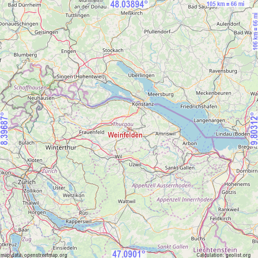
Weinfelden GPS coordinates[2]
47° 34' 0.012" North, 9° 6' 0" East
| Map corner | latitude | longitude |
|---|---|---|
| Upper-left | 48.03894°, | 8.39687° |
| Center: | 47.56667°, | 9.1° |
| Lower-right: | 47.0901°, | 9.80312° |
| Map W x H: | 105.5×105.5 km | = 65.6×65.6mi |
| max Lat: | 47.76737° ⇑4.2% North |
| Weinfelden: | 47.56667° |
| min Lat: | ⇓95.8% South 45.83203° |
| min Long | Weinfelden | max Long |
| 5.97153° | 9.1° | 10.44624° |
| W 90.9%⇐ | ⇒9.1% E |
Elevation
Elevation of Weinfelden is 429 m = 1407 ft, and this is 129.2 m = 424 ft below average elevation for this country.
| Max E: |
1845 m = 6053 ft | 76.3% |
| Avg. | 558.2 m = 1831 ft | |
| Weinfelden | 429 m = 1407 ft | |
Min E: |
197 m = 646 ft | 23.7% |
See also: Switzerland elevation on elevation.city.
Geographical zone
Weinfelden is located in North temperate zone (between Tropic of Cancer and the Arctic Circle). Distance of this North polar circle is 2112.3 km =1312.5 mi to North.| Distance of | km | miles | from Weinfelden |
|---|---|---|---|
| North Pole | 4718.1 | 2931.7 | to North |
| Arctic Circle | 2112.3 | 1312.5 | to North |
| Tropic Cancer | 2683 | 1667.1 | to South |
| Equator | 5288.9 | 3286.4 | to South |


Nearby cities:
15 places around Weinfelden: (largest is in red/bold)
• Affeltrangen
6.8 km =4.2 mi,  227°
227°
• Berg
5.2 km =3.2 mi,  74°
74°
• Bürglen
4.2 km =2.6 mi,  117°
117°
• Erlen
10.3 km =6.4 mi,  101°
101°
• Homburg
10.3 km =6.4 mi,  317°
317°
• Hüttlingen
9 km =5.6 mi,  278°
278°
• Lommis
9.5 km =5.9 mi, 234°
• Märstetten-Dorf
3.7 km =2.3 mi, 320°
• Müllheim
8.2 km =5.1 mi,  298°
298°
• Schönholzerswilen
6.3 km =3.9 mi,  150°
150°
• Sulgen
7.1 km =4.4 mi,  114°
114°
• Wigoltingen
6.2 km =3.9 mi, 303°
• Wuppenau
7.9 km =4.9 mi,  175°
175°
• Wäldi
7.5 km =4.7 mi,  357°
357°
• Zuzwil
10.3 km =6.4 mi,  174°
174°
Sources, notices
• [Note1] Compared only with cities in Switzerland existing in our database
• [Src1] Map data: © OpenStreetMap contributors (CC-BY-SA)
• [Src2] Other city data from geonames.org with taken over terms of usage.
• [Src3] Geographical zone / Annual Mean Temperature by Robert A. Rohde @ Wikipedia
