Bürglen geodata
Bürglen (Thurgau) is a populated place; located in Switzerland in Europe/Zurich (GMT+2) time zone. With population of 3,149 people, there are 561 cities with bigger population in this country. Compared to other cities in Switzerland, 94.9% of cities are located further ↓South; 92.2% of cities are located further ←West and 70.2% of cities have higher elevation than Bürglen. Note1


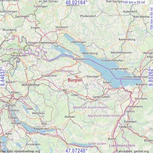
Bürglen GPS coordinates[2]
47° 32' 57.156" North, 9° 8' 58.2" East
| Map corner | latitude | longitude |
|---|---|---|
| Upper-left | 48.02164°, | 8.44637° |
| Center: | 47.54921°, | 9.1495° |
| Lower-right: | 47.07248°, | 9.85262° |
| Map W x H: | 105.5×105.5 km | = 65.6×65.6mi |
| max Lat: | 47.76737° ⇑5.1% North |
| Bürglen: | 47.54921° |
| min Lat: | ⇓94.9% South 45.83203° |
| min Long | Bürglen | max Long |
| 5.97153° | 9.1495° | 10.44624° |
| W 92.2%⇐ | ⇒7.8% E |
Elevation
Elevation of Bürglen is 439 m = 1440 ft, and this is 119.2 m = 391 ft below average elevation for this country.
| Max E: |
1845 m = 6053 ft | 70.2% |
| Avg. | 558.2 m = 1831 ft | |
| Bürglen | 439 m = 1440 ft | |
Min E: |
197 m = 646 ft | 29.8% |
See also: Switzerland elevation on elevation.city.
Geographical zone
Bürglen is located in North temperate zone (between Tropic of Cancer and the Arctic Circle). Distance of this North polar circle is 2114.2 km =1313.7 mi to North.| Distance of | km | miles | from Bürglen |
|---|---|---|---|
| North Pole | 4720.1 | 2932.9 | to North |
| Arctic Circle | 2114.2 | 1313.7 | to North |
| Tropic Cancer | 2681.1 | 1666 | to South |
| Equator | 5287 | 3285.2 | to South |


Nearby cities:
15 places around Bürglen: (largest is in red/bold)
• Affeltrangen
9.1 km =5.7 mi,  253°
253°
• Berg
3.5 km =2.2 mi,  21°
21°
• Erlen
6.4 km =4 mi,  91°
91°
• Hohentannen
7.2 km =4.5 mi,  128°
128°
• Langrickenbach
8.8 km =5.5 mi,  56°
56°
• Märstetten-Dorf
7.8 km =4.8 mi,  308°
308°
• Niederbüren
10.2 km =6.3 mi,  155°
155°
• Niederhelfenschwil
8.7 km =5.4 mi, 161°
• Schönholzerswilen
3.6 km =2.2 mi,  190°
190°
• Sulgen
2.9 km =1.8 mi,  111°
111°
• Weinfelden
4.2 km =2.6 mi,  297°
297°
• Wigoltingen
10.4 km =6.5 mi, 301°
• Wuppenau
6.6 km =4.1 mi,  207°
207°
• Wäldi
10.3 km =6.4 mi,  336°
336°
• Zuzwil
8.8 km =5.5 mi,  198°
198°
Sources, notices
• [Note1] Compared only with cities in Switzerland existing in our database
• [Src1] Map data: © OpenStreetMap contributors (CC-BY-SA)
• [Src2] Other city data from geonames.org with taken over terms of usage.
• [Src3] Geographical zone / Annual Mean Temperature by Robert A. Rohde @ Wikipedia
