Sulgen geodata
Sulgen (Thurgau) is a populated place; located in Switzerland in Europe/Zurich (GMT+2) time zone. With population of 3,367 people, there are 522 cities with bigger population in this country. Compared to other cities in Switzerland, 94.2% of cities are located further ↓South; 92.7% of cities are located further ←West and 54.2% of cities have higher elevation than Sulgen. Note1


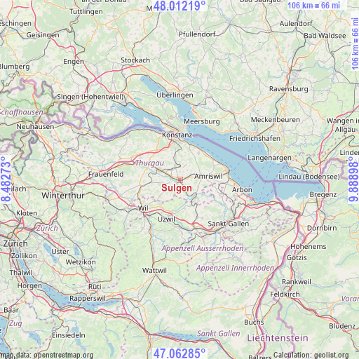
Sulgen GPS coordinates[2]
47° 32' 22.812" North, 9° 11' 9.06" East
| Map corner | latitude | longitude |
|---|---|---|
| Upper-left | 48.01219°, | 8.48273° |
| Center: | 47.53967°, | 9.18585° |
| Lower-right: | 47.06285°, | 9.88898° |
| Map W x H: | 105.6×105.6 km | = 65.6×65.6mi |
| max Lat: | 47.76737° ⇑5.8% North |
| Sulgen: | 47.53967° |
| min Lat: | ⇓94.2% South 45.83203° |
| min Long | Sulgen | max Long |
| 5.97153° | 9.18585° | 10.44624° |
| W 92.7%⇐ | ⇒7.3% E |
Elevation
Elevation of Sulgen is 469 m = 1539 ft, and this is 89.2 m = 293 ft below average elevation for this country.
| Max E: |
1845 m = 6053 ft | 54.2% |
| Avg. | 558.2 m = 1831 ft | |
| Sulgen | 469 m = 1539 ft | |
Min E: |
197 m = 646 ft | 45.8% |
See also: Switzerland elevation on elevation.city.
Geographical zone
Sulgen is located in North temperate zone (between Tropic of Cancer and the Arctic Circle). Distance of this North polar circle is 2115.3 km =1314.4 mi to North.| Distance of | km | miles | from Sulgen |
|---|---|---|---|
| North Pole | 4721.1 | 2933.6 | to North |
| Arctic Circle | 2115.3 | 1314.4 | to North |
| Tropic Cancer | 2680 | 1665.3 | to South |
| Equator | 5285.9 | 3284.5 | to South |


Nearby cities:
15 places around Sulgen: (largest is in red/bold)
• Altnau
9.7 km =6 mi,  35°
35°
• Amriswil
8.3 km =5.2 mi,  84°
84°
• Berg
4.6 km =2.9 mi,  341°
341°
• Bürglen
2.9 km =1.8 mi,  291°
291°
• Erlen
3.7 km =2.3 mi, 75°
• Güttingen
10.4 km =6.5 mi,  47°
47°
• Hohentannen
4.5 km =2.8 mi,  139°
139°
• Langrickenbach
7.6 km =4.7 mi, 37°
• Muolen
10.6 km =6.6 mi,  101°
101°
• Niederbüren
8.4 km =5.2 mi,  169°
169°
• Niederhelfenschwil
7.2 km =4.5 mi,  180°
180°
• Schönholzerswilen
4.2 km =2.6 mi,  233°
233°
• Weinfelden
7.1 km =4.4 mi, 294°
• Wuppenau
7.5 km =4.7 mi, 230°
• Zuzwil
9.1 km =5.7 mi,  217°
217°
Sources, notices
• [Note1] Compared only with cities in Switzerland existing in our database
• [Src1] Map data: © OpenStreetMap contributors (CC-BY-SA)
• [Src2] Other city data from geonames.org with taken over terms of usage.
• [Src3] Geographical zone / Annual Mean Temperature by Robert A. Rohde @ Wikipedia
