Unterlunkhofen geodata
Unterlunkhofen (Aargau) is a seat of a third-order administrative division; located in Switzerland in Europe/Zurich (GMT+2) time zone. With population of 1,263 people, there are 1156 cities with bigger population in this country. Compared to other cities in Switzerland, 61.2% of cities are located further ↓South; 51.2% of cities are located further →East and 89.9% of cities have higher elevation than Unterlunkhofen. Note1


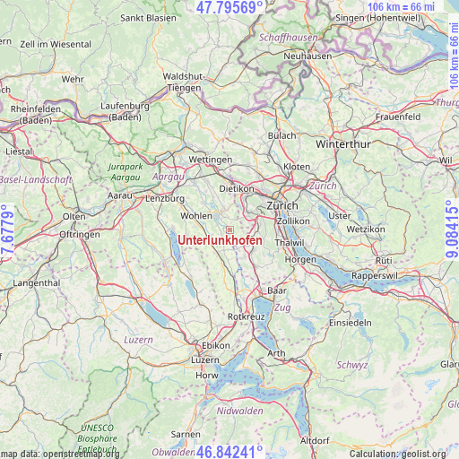
Unterlunkhofen GPS coordinates[2]
47° 19' 16.32" North, 8° 22' 51.672" East
| Map corner | latitude | longitude |
|---|---|---|
| Upper-left | 47.79569°, | 7.6779° |
| Center: | 47.3212°, | 8.38102° |
| Lower-right: | 46.84241°, | 9.08415° |
| Map W x H: | 106×106 km | = 65.9×65.9mi |
| max Lat: | 47.76737° ⇑38.8% North |
| Unterlunkhofen: | 47.3212° |
| min Lat: | ⇓61.2% South 45.83203° |
| min Long | Unterlunkhofen | max Long |
| 5.97153° | 8.38102° | 10.44624° |
| W 48.8%⇐ | ⇒51.2% E |
Elevation
Elevation of Unterlunkhofen is 395 m = 1296 ft, and this is 163.2 m = 535 ft below average elevation for this country.
| Max E: |
1845 m = 6053 ft | 89.9% |
| Avg. | 558.2 m = 1831 ft | |
| Unterlunkhofen | 395 m = 1296 ft | |
Min E: |
197 m = 646 ft | 10.1% |
See also: Switzerland elevation on elevation.city.
Geographical zone
Unterlunkhofen is located in North temperate zone (between Tropic of Cancer and the Arctic Circle). Distance of this North polar circle is 2139.5 km =1329.4 mi to North.| Distance of | km | miles | from Unterlunkhofen |
|---|---|---|---|
| North Pole | 4745.4 | 2948.7 | to North |
| Arctic Circle | 2139.5 | 1329.4 | to North |
| Tropic Cancer | 2655.7 | 1650.2 | to South |
| Equator | 5261.6 | 3269.4 | to South |


Nearby cities:
15 places around Unterlunkhofen: (largest is in red/bold)
• Aesch
4.8 km =3 mi,  69°
69°
• Aristau
4 km =2.5 mi,  199°
199°
• Berikon
3.4 km =2.1 mi,  349°
349°
• Besenbüren
2.8 km =1.7 mi,  254°
254°
• Birmensdorf
6 km =3.7 mi,  50°
50°
• Bremgarten
4.4 km =2.7 mi,  318°
318°
• Bünzen
4.5 km =2.8 mi, 253°
• Hedingen
5.7 km =3.5 mi,  117°
117°
• Jonen
2.8 km =1.7 mi,  161°
161°
• Muri
6.1 km =3.8 mi,  211°
211°
• Oberlunkhofen
1.3 km =0.8 mi,  138°
138°
• Ottenbach
4.7 km =2.9 mi, 157°
• Rottenschwil
1.7 km =1.1 mi,  240°
240°
• Rudolfstetten
5.5 km =3.4 mi,  359°
359°
• Zwillikon
5.3 km =3.3 mi,  133°
133°
Sources, notices
• [Note1] Compared only with cities in Switzerland existing in our database
• [Src1] Map data: © OpenStreetMap contributors (CC-BY-SA)
• [Src2] Other city data from geonames.org with taken over terms of usage.
• [Src3] Geographical zone / Annual Mean Temperature by Robert A. Rohde @ Wikipedia
