Besenbüren geodata
Besenbüren (Aargau) is a seat of a third-order administrative division; located in Switzerland in Europe/Zurich (GMT+1) time zone. In our database, there are 1823 cities with bigger population. Compared to other cities in Switzerland, 60% of cities are located further ↓South; 52.1% of cities are located further →East and 54.8% of cities have higher elevation than Besenbüren. Note1


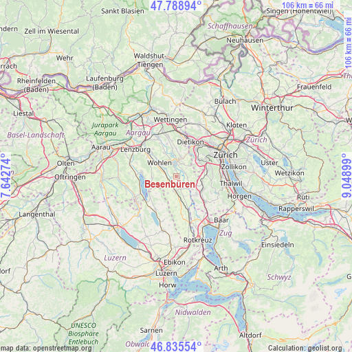
Besenbüren GPS coordinates[2]
47° 18' 51.804" North, 8° 20' 45.096" East
| Map corner | latitude | longitude |
|---|---|---|
| Upper-left | 47.78894°, | 7.64274° |
| Center: | 47.31439°, | 8.34586° |
| Lower-right: | 46.83554°, | 9.04899° |
| Map W x H: | 106×106 km | = 65.9×65.9mi |
| max Lat: | 47.76737° ⇑40% North |
| Besenbüren: | 47.31439° |
| min Lat: | ⇓60% South 45.83203° |
| min Long | Besenbüren | max Long |
| 5.97153° | 8.34586° | 10.44624° |
| W 47.9%⇐ | ⇒52.1% E |
Elevation
Elevation of Besenbüren is 468 m = 1535 ft, and this is 90.2 m = 296 ft below average elevation for this country.
| Max E: |
1845 m = 6053 ft | 54.8% |
| Avg. | 558.2 m = 1831 ft | |
| Besenbüren | 468 m = 1535 ft | |
Min E: |
197 m = 646 ft | 45.2% |
See also: Switzerland elevation on elevation.city.
Geographical zone
Besenbüren is located in North temperate zone (between Tropic of Cancer and the Arctic Circle). Distance of this North polar circle is 2140.3 km =1329.9 mi to North.| Distance of | km | miles | from Besenbüren |
|---|---|---|---|
| North Pole | 4746.2 | 2949.2 | to North |
| Arctic Circle | 2140.3 | 1329.9 | to North |
| Tropic Cancer | 2654.9 | 1649.7 | to South |
| Equator | 5260.9 | 3269 | to South |


Nearby cities:
15 places around Besenbüren: (largest is in red/bold)
• Aristau
3.3 km =2.1 mi,  156°
156°
• Berikon
4.6 km =2.9 mi,  25°
25°
• Bremgarten
4.1 km =2.5 mi,  356°
356°
• Buttwil
5.8 km =3.6 mi,  207°
207°
• Bünzen
1.7 km =1.1 mi,  252°
252°
• Jonen
4 km =2.5 mi,  117°
117°
• Merenschwand
6.5 km =4 mi, 159°
• Muri
4.5 km =2.8 mi,  187°
187°
• Oberlunkhofen
3.5 km =2.2 mi,  93°
93°
• Ottenbach
5.7 km =3.5 mi,  129°
129°
• Rottenschwil
1.2 km =0.7 mi, 93°
• Rudolfstetten
6.8 km =4.2 mi,  22°
22°
• Unterlunkhofen
2.8 km =1.7 mi,  74°
74°
• Waltenschwil
4.2 km =2.6 mi,  300°
300°
• Wohlen
6.7 km =4.2 mi,  307°
307°
Sources, notices
• [Note1] Compared only with cities in Switzerland existing in our database
• [Src1] Map data: © OpenStreetMap contributors (CC-BY-SA)
• [Src2] Other city data from geonames.org with taken over terms of usage.
• [Src3] Geographical zone / Annual Mean Temperature by Robert A. Rohde @ Wikipedia
