Berikon geodata
Berikon (Aargau) is a populated place; located in Switzerland in Europe/Zurich (GMT+2) time zone. With population of 4,527 people, there are 380 cities with bigger population in this country. Compared to other cities in Switzerland, 64.9% of cities are located further ↓South; 51.5% of cities are located further →East and 65.1% of cities have lower elevation than Berikon. Note1


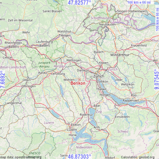
Berikon GPS coordinates[2]
47° 21' 5.58" North, 8° 22' 20.352" East
| Map corner | latitude | longitude |
|---|---|---|
| Upper-left | 47.82577°, | 7.6692° |
| Center: | 47.35155°, | 8.37232° |
| Lower-right: | 46.87303°, | 9.07545° |
| Map W x H: | 105.9×105.9 km | = 65.8×65.8mi |
| max Lat: | 47.76737° ⇑35.1% North |
| Berikon: | 47.35155° |
| min Lat: | ⇓64.9% South 45.83203° |
| min Long | Berikon | max Long |
| 5.97153° | 8.37232° | 10.44624° |
| W 48.5%⇐ | ⇒51.5% E |
Elevation
Elevation of Berikon is 547 m = 1795 ft, and this is 11.2 m = 37 ft below average elevation for this country.
| Max E: |
1845 m = 6053 ft | 34.9% |
| Avg. | 558.2 m = 1831 ft | |
| Berikon | 547 m = 1795 ft | |
Min E: |
197 m = 646 ft | 65.1% |
See also: Switzerland elevation on elevation.city.
Geographical zone
Berikon is located in North temperate zone (between Tropic of Cancer and the Arctic Circle). Distance of this North polar circle is 2136.2 km =1327.4 mi to North.| Distance of | km | miles | from Berikon |
|---|---|---|---|
| North Pole | 4742.1 | 2946.6 | to North |
| Arctic Circle | 2136.2 | 1327.4 | to North |
| Tropic Cancer | 2659.1 | 1652.3 | to South |
| Equator | 5265 | 3271.5 | to South |


Nearby cities:
15 places around Berikon: (largest is in red/bold)
• Aesch
5.4 km =3.4 mi,  107°
107°
• Besenbüren
4.6 km =2.9 mi,  205°
205°
• Birmensdorf
5.3 km =3.3 mi,  85°
85°
• Bremgarten
2.3 km =1.4 mi,  268°
268°
• Dietikon / Rütematt
5.2 km =3.2 mi,  24°
24°
• Künten
5.2 km =3.2 mi,  322°
322°
• Oberlunkhofen
4.6 km =2.9 mi,  160°
160°
• Rottenschwil
4.3 km =2.7 mi,  191°
191°
• Rudolfstetten
2.3 km =1.4 mi, 16°
• Unterlunkhofen
3.4 km =2.1 mi,  169°
169°
• Urdorf
5.5 km =3.4 mi,  47°
47°
• Urdorf / Baumgarten
4.8 km =3 mi, 50°
• Urdorf / Fadmatt
5.4 km =3.4 mi, 51°
• Urdorf / Oberurdorf
5 km =3.1 mi, 49°
• Urdorf / Zentrum
5.4 km =3.4 mi, 45°
Sources, notices
• [Note1] Compared only with cities in Switzerland existing in our database
• [Src1] Map data: © OpenStreetMap contributors (CC-BY-SA)
• [Src2] Other city data from geonames.org with taken over terms of usage.
• [Src3] Geographical zone / Annual Mean Temperature by Robert A. Rohde @ Wikipedia
