Waldenburg geodata
Waldenburg (Basel-Landschaft) is a seat of a second-order administrative division; located in Switzerland in Europe/Zurich (GMT+2) time zone. With population of 1,337 people, there are 1111 cities with bigger population in this country. Compared to other cities in Switzerland, 69.6% of cities are located further ↓South; 67% of cities are located further →East and 64.5% of cities have lower elevation than Waldenburg. Note1
Administrative division(s):
- Level 1: Basel-Landschaft
- Level 2: Bezirk Waldenburg
- Level 3: Waldenburg


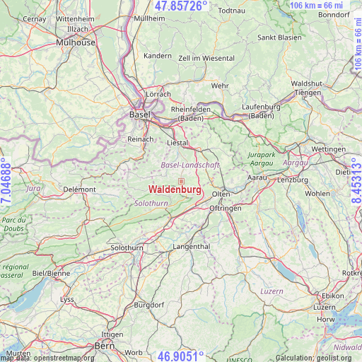
Waldenburg GPS coordinates[2]
47° 22' 59.988" North, 7° 45' 0" East
| Map corner | latitude | longitude |
|---|---|---|
| Upper-left | 47.85726°, | 7.04688° |
| Center: | 47.38333°, | 7.75° |
| Lower-right: | 46.9051°, | 8.45313° |
| Map W x H: | 105.9×105.9 km | = 65.8×65.8mi |
| max Lat: | 47.76737° ⇑30.4% North |
| Waldenburg: | 47.38333° |
| min Lat: | ⇓69.6% South 45.83203° |
| min Long | Waldenburg | max Long |
| 5.97153° | 7.75° | 10.44624° |
| W 33%⇐ | ⇒67% E |
Elevation
Elevation of Waldenburg is 544 m = 1785 ft, and this is 14.2 m = 47 ft below average elevation for this country.
| Max E: |
1845 m = 6053 ft | 35.5% |
| Avg. | 558.2 m = 1831 ft | |
| Waldenburg | 544 m = 1785 ft | |
Min E: |
197 m = 646 ft | 64.5% |
See also: Switzerland elevation on elevation.city.
Geographical zone
Waldenburg is located in North temperate zone (between Tropic of Cancer and the Arctic Circle). Distance of this North polar circle is 2132.6 km =1325.1 mi to North.| Distance of | km | miles | from Waldenburg |
|---|---|---|---|
| North Pole | 4738.5 | 2944.4 | to North |
| Arctic Circle | 2132.6 | 1325.1 | to North |
| Tropic Cancer | 2662.6 | 1654.5 | to South |
| Equator | 5268.5 | 3273.7 | to South |


Nearby cities:
15 places around Waldenburg: (largest is in red/bold)
• Arboldswil
4.2 km =2.6 mi,  324°
324°
• Bretzwil
7.5 km =4.7 mi,  282°
282°
• Bubendorf
7 km =4.3 mi,  352°
352°
• Buckten
7.7 km =4.8 mi,  67°
67°
• Diegten
5.7 km =3.5 mi,  53°
53°
• Egerkingen
7.5 km =4.7 mi,  160°
160°
• Holderbank
5.6 km =3.5 mi,  178°
178°
• Hölstein
4.7 km =2.9 mi,  19°
19°
• Känerkinden
7.3 km =4.5 mi,  64°
64°
• Langenbruck
4 km =2.5 mi, 160°
• Läufelfingen
8.1 km =5 mi,  81°
81°
• Oberbuchsiten
7.9 km =4.9 mi,  169°
169°
• Oberdorf
1.1 km =0.7 mi,  6°
6°
• Reigoldswil
5 km =3.1 mi,  289°
289°
• Tenniken
7.6 km =4.7 mi,  37°
37°
Sources, notices
• [Note1] Compared only with cities in Switzerland existing in our database
• [Src1] Map data: © OpenStreetMap contributors (CC-BY-SA)
• [Src2] Other city data from geonames.org with taken over terms of usage.
• [Src3] Geographical zone / Annual Mean Temperature by Robert A. Rohde @ Wikipedia
