Reigoldswil geodata
Reigoldswil (Basel-Landschaft) is a populated place; located in Switzerland in Europe/Zurich (GMT+2) time zone. With population of 1,509 people, there are 1030 cities with bigger population in this country. Compared to other cities in Switzerland, 73.5% of cities are located further ↓South; 68.7% of cities are located further →East and 61.9% of cities have lower elevation than Reigoldswil. Note1
Administrative division(s):
- Level 1: Basel-Landschaft
- Level 2: Bezirk Waldenburg
- Level 3: Reigoldswil


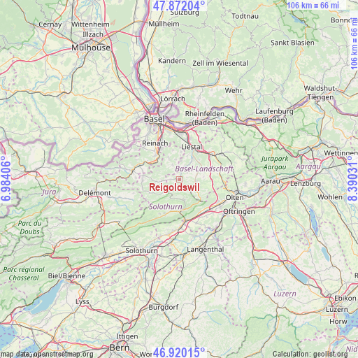
Reigoldswil GPS coordinates[2]
47° 23' 53.664" North, 7° 41' 13.848" East
| Map corner | latitude | longitude |
|---|---|---|
| Upper-left | 47.87204°, | 6.98406° |
| Center: | 47.39824°, | 7.68718° |
| Lower-right: | 46.92015°, | 8.39031° |
| Map W x H: | 105.8×105.8 km | = 65.7×65.7mi |
| max Lat: | 47.76737° ⇑26.5% North |
| Reigoldswil: | 47.39824° |
| min Lat: | ⇓73.5% South 45.83203° |
| min Long | Reigoldswil | max Long |
| 5.97153° | 7.68718° | 10.44624° |
| W 31.3%⇐ | ⇒68.7% E |
Elevation
Elevation of Reigoldswil is 531 m = 1742 ft, and this is 27.2 m = 89 ft below average elevation for this country.
| Max E: |
1845 m = 6053 ft | 38.1% |
| Avg. | 558.2 m = 1831 ft | |
| Reigoldswil | 531 m = 1742 ft | |
Min E: |
197 m = 646 ft | 61.9% |
See also: Switzerland elevation on elevation.city.
Geographical zone
Reigoldswil is located in North temperate zone (between Tropic of Cancer and the Arctic Circle). Distance of this North polar circle is 2131 km =1324.1 mi to North.| Distance of | km | miles | from Reigoldswil |
|---|---|---|---|
| North Pole | 4736.9 | 2943.4 | to North |
| Arctic Circle | 2131 | 1324.1 | to North |
| Tropic Cancer | 2664.3 | 1655.5 | to South |
| Equator | 5270.2 | 3274.7 | to South |


Nearby cities:
15 places around Reigoldswil: (largest is in red/bold)
• Arboldswil
2.9 km =1.8 mi,  51°
51°
• Bretzwil
2.6 km =1.6 mi,  269°
269°
• Bubendorf
6.5 km =4 mi,  35°
35°
• Gempen
8.9 km =5.5 mi,  346°
346°
• Grellingen
8.9 km =5.5 mi,  303°
303°
• Himmelried
7.1 km =4.4 mi,  291°
291°
• Hochwald
7 km =4.3 mi,  332°
332°
• Holderbank
8.8 km =5.5 mi,  145°
145°
• Hölstein
6.8 km =4.2 mi,  66°
66°
• Langenbruck
8.2 km =5.1 mi,  131°
131°
• Nunningen
5.1 km =3.2 mi,  264°
264°
• Oberdorf
4.9 km =3 mi,  96°
96°
• Seltisberg
7.6 km =4.7 mi,  19°
19°
• Waldenburg
5 km =3.1 mi,  109°
109°
• Zullwil
6.6 km =4.1 mi, 263°
Sources, notices
• [Note1] Compared only with cities in Switzerland existing in our database
• [Src1] Map data: © OpenStreetMap contributors (CC-BY-SA)
• [Src2] Other city data from geonames.org with taken over terms of usage.
• [Src3] Geographical zone / Annual Mean Temperature by Robert A. Rohde @ Wikipedia
