Läufelfingen geodata
Läufelfingen (Basel-Landschaft) is a populated place; located in Switzerland in Europe/Zurich (GMT+2) time zone. With population of 1,271 people, there are 1151 cities with bigger population in this country. Compared to other cities in Switzerland, 72.3% of cities are located further ↓South; 63.9% of cities are located further →East and 67% of cities have lower elevation than Läufelfingen. Note1


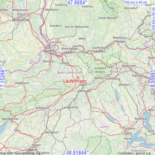
Läufelfingen GPS coordinates[2]
47° 23' 40.452" North, 7° 51' 20.808" East
| Map corner | latitude | longitude |
|---|---|---|
| Upper-left | 47.8684°, | 7.15266° |
| Center: | 47.39457°, | 7.85578° |
| Lower-right: | 46.91644°, | 8.55891° |
| Map W x H: | 105.8×105.8 km | = 65.7×65.7mi |
| max Lat: | 47.76737° ⇑27.7% North |
| Läufelfingen: | 47.39457° |
| min Lat: | ⇓72.3% South 45.83203° |
| min Long | Läufelfingen | max Long |
| 5.97153° | 7.85578° | 10.44624° |
| W 36.1%⇐ | ⇒63.9% E |
Elevation
Elevation of Läufelfingen is 557 m = 1827 ft, and this is 1.2 m = 4 ft below average elevation for this country.
| Max E: |
1845 m = 6053 ft | 33% |
| Avg. | 558.2 m = 1831 ft | |
| Läufelfingen | 557 m = 1827 ft | |
Min E: |
197 m = 646 ft | 67% |
See also: Switzerland elevation on elevation.city.
Geographical zone
Läufelfingen is located in North temperate zone (between Tropic of Cancer and the Arctic Circle). Distance of this North polar circle is 2131.4 km =1324.4 mi to North.| Distance of | km | miles | from Läufelfingen |
|---|---|---|---|
| North Pole | 4737.3 | 2943.6 | to North |
| Arctic Circle | 2131.4 | 1324.4 | to North |
| Tropic Cancer | 2663.9 | 1655.3 | to South |
| Equator | 5269.8 | 3274.5 | to South |


Nearby cities:
15 places around Läufelfingen: (largest is in red/bold)
• Buckten
1.9 km =1.2 mi,  334°
334°
• Diegten
4 km =2.5 mi,  302°
302°
• Hägendorf
6.7 km =4.2 mi,  189°
189°
• Hölstein
7.2 km =4.5 mi, 296°
• Känerkinden
2.4 km =1.5 mi,  323°
323°
• Lostorf
6.9 km =4.3 mi,  100°
100°
• Olten
6.1 km =3.8 mi,  144°
144°
• Rohr
7.5 km =4.7 mi,  76°
76°
• Rünenberg
4.8 km =3 mi,  24°
24°
• Tecknau
6.4 km =4 mi, 19°
• Tenniken
5.8 km =3.6 mi, 324°
• Trimbach
4 km =2.5 mi, 144°
• Wangen
5.8 km =3.6 mi,  169°
169°
• Zeglingen
4.6 km =2.9 mi,  56°
56°
• Zunzgen
7.1 km =4.4 mi, 329°
Sources, notices
• [Note1] Compared only with cities in Switzerland existing in our database
• [Src1] Map data: © OpenStreetMap contributors (CC-BY-SA)
• [Src2] Other city data from geonames.org with taken over terms of usage.
• [Src3] Geographical zone / Annual Mean Temperature by Robert A. Rohde @ Wikipedia
