Diegten geodata
Diegten (Basel-Landschaft) is a populated place; located in Switzerland in Europe/Zurich (GMT+2) time zone. With population of 1,633 people, there are 966 cities with bigger population in this country. Compared to other cities in Switzerland, 76.4% of cities are located further ↓South; 65.2% of cities are located further →East and 54.8% of cities have higher elevation than Diegten. Note1


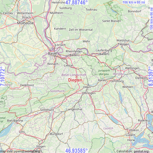
Diegten GPS coordinates[2]
47° 24' 49.68" North, 7° 48' 39.06" East
| Map corner | latitude | longitude |
|---|---|---|
| Upper-left | 47.88746°, | 7.10772° |
| Center: | 47.4138°, | 7.81085° |
| Lower-right: | 46.93585°, | 8.51397° |
| Map W x H: | 105.8×105.8 km | = 65.7×65.7mi |
| max Lat: | 47.76737° ⇑23.6% North |
| Diegten: | 47.4138° |
| min Lat: | ⇓76.4% South 45.83203° |
| min Long | Diegten | max Long |
| 5.97153° | 7.81085° | 10.44624° |
| W 34.8%⇐ | ⇒65.2% E |
Elevation
Elevation of Diegten is 468 m = 1535 ft, and this is 90.2 m = 296 ft below average elevation for this country.
| Max E: |
1845 m = 6053 ft | 54.8% |
| Avg. | 558.2 m = 1831 ft | |
| Diegten | 468 m = 1535 ft | |
Min E: |
197 m = 646 ft | 45.2% |
See also: Switzerland elevation on elevation.city.
Geographical zone
Diegten is located in North temperate zone (between Tropic of Cancer and the Arctic Circle). Distance of this North polar circle is 2129.3 km =1323.1 mi to North.| Distance of | km | miles | from Diegten |
|---|---|---|---|
| North Pole | 4735.1 | 2942.3 | to North |
| Arctic Circle | 2129.3 | 1323.1 | to North |
| Tropic Cancer | 2666 | 1656.6 | to South |
| Equator | 5271.9 | 3275.8 | to South |


Nearby cities:
15 places around Diegten: (largest is in red/bold)
• Arboldswil
7 km =4.3 mi,  270°
270°
• Bubendorf
6.6 km =4.1 mi,  302°
302°
• Buckten
2.6 km =1.6 mi,  99°
99°
• Gelterkinden
6.5 km =4 mi,  28°
28°
• Hölstein
3.2 km =2 mi,  288°
288°
• Itingen
6.2 km =3.9 mi,  341°
341°
• Känerkinden
2 km =1.2 mi, 96°
• Läufelfingen
4 km =2.5 mi,  122°
122°
• Oberdorf
5 km =3.1 mi,  243°
243°
• Rünenberg
5.8 km =3.6 mi,  67°
67°
• Sissach
5.6 km =3.5 mi,  358°
358°
• Tecknau
6.8 km =4.2 mi,  54°
54°
• Tenniken
2.6 km =1.6 mi,  1°
1°
• Waldenburg
5.7 km =3.5 mi,  233°
233°
• Zunzgen
3.9 km =2.4 mi, 356°
Sources, notices
• [Note1] Compared only with cities in Switzerland existing in our database
• [Src1] Map data: © OpenStreetMap contributors (CC-BY-SA)
• [Src2] Other city data from geonames.org with taken over terms of usage.
• [Src3] Geographical zone / Annual Mean Temperature by Robert A. Rohde @ Wikipedia
