Sottens geodata
Sottens (Vaud) is a seat of a third-order administrative division; located in Switzerland in Europe/Zurich (GMT+2) time zone. With population of 209 people, there are 1817 cities with bigger population in this country. Compared to other cities in Switzerland, 80.4% of cities are located further ↑North; 92.2% of cities are located further →East and 86.3% of cities have lower elevation than Sottens. Note1


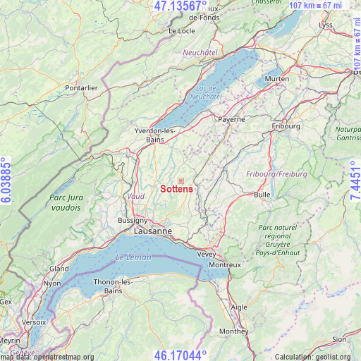
Sottens GPS coordinates[2]
46° 39' 18.756" North, 6° 44' 31.092" East
| Map corner | latitude | longitude |
|---|---|---|
| Upper-left | 47.13567°, | 6.03885° |
| Center: | 46.65521°, | 6.74197° |
| Lower-right: | 46.17044°, | 7.4451° |
| Map W x H: | 107.3×107.3 km | = 66.7×66.7mi |
| max Lat: | 47.76737° ⇑80.4% North |
| Sottens: | 46.65521° |
| min Lat: | ⇓19.6% South 45.83203° |
| min Long | Sottens | max Long |
| 5.97153° | 6.74197° | 10.44624° |
| W 7.8%⇐ | ⇒92.2% E |
Elevation
Elevation of Sottens is 754 m = 2474 ft, and this is 195.8 m = 642 ft above average elevation for this country.
| Max E: |
1845 m = 6053 ft | 13.7% |
| Sottens | 754 m 2474 ft | |
| Avg. | 558.2 m = 1831 ft | |
Min E: |
197 m = 646 ft | 86.3% |
See also: Switzerland elevation on elevation.city.
Geographical zone
Sottens is located in North temperate zone (between Tropic of Cancer and the Arctic Circle). Distance of this North polar circle is 2213.6 km =1375.5 mi to North.| Distance of | km | miles | from Sottens |
|---|---|---|---|
| North Pole | 4819.5 | 2994.7 | to North |
| Arctic Circle | 2213.6 | 1375.5 | to North |
| Tropic Cancer | 2581.7 | 1604.2 | to South |
| Equator | 5187.6 | 3223.4 | to South |


Nearby cities:
15 places around Sottens: (largest is in red/bold)
• Assens
10.3 km =6.4 mi,  242°
242°
• Bercher
4.8 km =3 mi,  326°
326°
• Bottens
7.5 km =4.7 mi,  234°
234°
• Corcelles-le-Jorat
5.4 km =3.4 mi,  179°
179°
• Echallens
8.4 km =5.2 mi,  259°
259°
• Ecublens
7.4 km =4.6 mi,  136°
136°
• Froideville
7.6 km =4.7 mi,  217°
217°
• Lucens
9.5 km =5.9 mi,  51°
51°
• Moudon
4.5 km =2.8 mi,  72°
72°
• Pailly
7.2 km =4.5 mi,  315°
315°
• Rue
7.3 km =4.5 mi,  123°
123°
• Rueyres
5.7 km =3.5 mi, 318°
• Servion
9.8 km =6.1 mi,  163°
163°
• Thierrens
5.5 km =3.4 mi,  10°
10°
• Vuarrens
7.9 km =4.9 mi,  295°
295°
Sources, notices
• [Note1] Compared only with cities in Switzerland existing in our database
• [Src1] Map data: © OpenStreetMap contributors (CC-BY-SA)
• [Src2] Other city data from geonames.org with taken over terms of usage.
• [Src3] Geographical zone / Annual Mean Temperature by Robert A. Rohde @ Wikipedia
