Scanfs geodata
Scanfs (Grisons) is a populated place; located in Switzerland in Europe/Zurich (GMT+2) time zone. With population of 701 people, there are 1596 cities with bigger population in this country. Compared to other cities in Switzerland, 81.9% of cities are located further ↑North; 99.6% of cities are located further ←West and 99.4% of cities have lower elevation than Scanfs. Note1


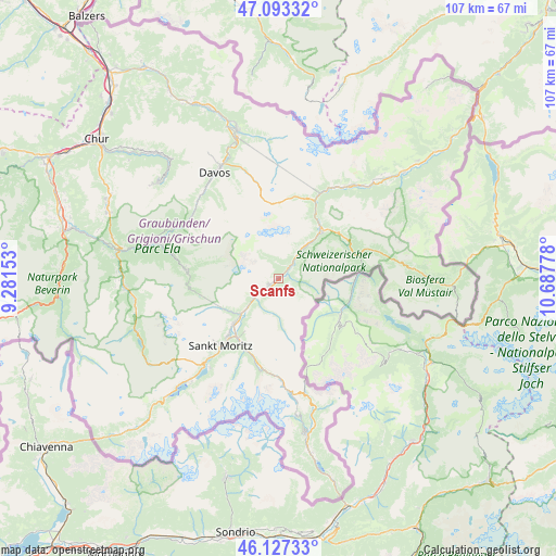
Scanfs GPS coordinates[2]
46° 36' 44.928" North, 9° 59' 4.74" East
| Map corner | latitude | longitude |
|---|---|---|
| Upper-left | 47.09332°, | 9.28153° |
| Center: | 46.61248°, | 9.98465° |
| Lower-right: | 46.12733°, | 10.68778° |
| Map W x H: | 107.4×107.4 km | = 66.7×66.7mi |
| max Lat: | 47.76737° ⇑81.9% North |
| Scanfs: | 46.61248° |
| min Lat: | ⇓18.1% South 45.83203° |
| min Long | Scanfs | max Long |
| 5.97153° | 9.98465° | 10.44624° |
| W 99.6%⇐ | ⇒0.40000000000001% E |
Elevation
Elevation of Scanfs is 1671 m = 5482 ft, and this is 1112.8 m = 3651 ft above average elevation for this country.
| Max E: |
1845 m = 6053 ft | 0.59999999999999% |
| Scanfs | 1671 m 5482 ft | |
| Avg. | 558.2 m = 1831 ft | |
Min E: |
197 m = 646 ft | 99.4% |
See also: Switzerland elevation on elevation.city.
Geographical zone
Scanfs is located in North temperate zone (between Tropic of Cancer and the Arctic Circle). Distance of this North polar circle is 2218.4 km =1378.4 mi to North.| Distance of | km | miles | from Scanfs |
|---|---|---|---|
| North Pole | 4824.2 | 2997.6 | to North |
| Arctic Circle | 2218.4 | 1378.4 | to North |
| Tropic Cancer | 2576.9 | 1601.2 | to South |
| Equator | 5182.8 | 3220.4 | to South |


Nearby cities:
15 places around Scanfs: (largest is in red/bold)
• Arosa
29.9 km =18.6 mi,  308°
308°
• Bergün
18.2 km =11.3 mi,  275°
275°
• Celerina
14.8 km =9.2 mi,  220°
220°
• Davos
24.1 km =15 mi,  332°
332°
• Filisur
23.8 km =14.8 mi,  286°
286°
• La Punt Chamues-ch
6.2 km =3.9 mi,  232°
232°
• Pontresina
14.5 km =9 mi,  206°
206°
• Samedan
12.2 km =7.6 mi, 224°
• Savognin
29.6 km =18.4 mi,  266°
266°
• Sils-Segl Maria
26.5 km =16.5 mi, 219°
• Silvaplana
22.5 km =14 mi, 220°
• St. Moritz
16.6 km =10.3 mi, 220°
• Tiefencastel
31.4 km =19.5 mi, 279°
• Zernez
12.6 km =7.8 mi,  40°
40°
• Zuoz
2.2 km =1.4 mi,  238°
238°
Sources, notices
• [Note1] Compared only with cities in Switzerland existing in our database
• [Src1] Map data: © OpenStreetMap contributors (CC-BY-SA)
• [Src2] Other city data from geonames.org with taken over terms of usage.
• [Src3] Geographical zone / Annual Mean Temperature by Robert A. Rohde @ Wikipedia
