Aarburg geodata
Aarburg (Aargau) is a populated place; located in Switzerland in Europe/Zurich (GMT+2) time zone. With population of 6,828 people, there are 234 cities with bigger population in this country. Compared to other cities in Switzerland, 61% of cities are located further ↓South; 62.5% of cities are located further →East and 85.9% of cities have higher elevation than Aarburg. Note1


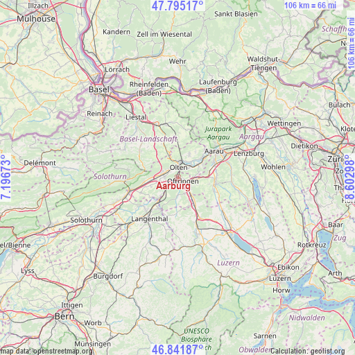
Aarburg GPS coordinates[2]
47° 19' 14.412" North, 7° 53' 59.496" East
| Map corner | latitude | longitude |
|---|---|---|
| Upper-left | 47.79517°, | 7.19673° |
| Center: | 47.32067°, | 7.89986° |
| Lower-right: | 46.84187°, | 8.60298° |
| Map W x H: | 106×106 km | = 65.9×65.9mi |
| max Lat: | 47.76737° ⇑39% North |
| Aarburg: | 47.32067° |
| min Lat: | ⇓61% South 45.83203° |
| min Long | Aarburg | max Long |
| 5.97153° | 7.89986° | 10.44624° |
| W 37.5%⇐ | ⇒62.5% E |
Elevation
Elevation of Aarburg is 408 m = 1339 ft, and this is 150.2 m = 493 ft below average elevation for this country.
| Max E: |
1845 m = 6053 ft | 85.9% |
| Avg. | 558.2 m = 1831 ft | |
| Aarburg | 408 m = 1339 ft | |
Min E: |
197 m = 646 ft | 14.1% |
See also: Switzerland elevation on elevation.city.
Geographical zone
Aarburg is located in North temperate zone (between Tropic of Cancer and the Arctic Circle). Distance of this North polar circle is 2139.6 km =1329.5 mi to North.| Distance of | km | miles | from Aarburg |
|---|---|---|---|
| North Pole | 4745.5 | 2948.7 | to North |
| Arctic Circle | 2139.6 | 1329.5 | to North |
| Tropic Cancer | 2655.6 | 1650.1 | to South |
| Equator | 5261.6 | 3269.4 | to South |


Nearby cities:
15 places around Aarburg: (largest is in red/bold)
• Brittnau
7.7 km =4.8 mi,  152°
152°
• Fulenbach
7.6 km =4.7 mi,  223°
223°
• Gunzgen
5.2 km =3.2 mi,  261°
261°
• Hägendorf
4.7 km =2.9 mi,  289°
289°
• Murgenthal
7.1 km =4.4 mi, 219°
• Obergösgen
6.3 km =3.9 mi,  38°
38°
• Oftringen
2.1 km =1.3 mi,  111°
111°
• Olten
3.3 km =2.1 mi,  4°
4°
• Rothrist
1.8 km =1.1 mi,  198°
198°
• Safenwil
6.2 km =3.9 mi,  89°
89°
• Strengelbach
5.1 km =3.2 mi, 154°
• Trimbach
5.1 km =3.2 mi,  348°
348°
• Vordemwald
5 km =3.1 mi,  178°
178°
• Wangen
3.4 km =2.1 mi,  318°
318°
• Zofingen
5 km =3.1 mi,  136°
136°
Sources, notices
• [Note1] Compared only with cities in Switzerland existing in our database
• [Src1] Map data: © OpenStreetMap contributors (CC-BY-SA)
• [Src2] Other city data from geonames.org with taken over terms of usage.
• [Src3] Geographical zone / Annual Mean Temperature by Robert A. Rohde @ Wikipedia
