Roggwil geodata
Roggwil (Thurgau) is a populated place; located in Switzerland in Europe/Zurich (GMT+2) time zone. With population of 2,500 people, there are 695 cities with bigger population in this country. Compared to other cities in Switzerland, 89.2% of cities are located further ↓South; 95.1% of cities are located further ←West and 70.8% of cities have higher elevation than Roggwil. Note1


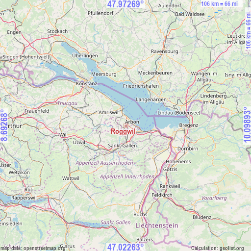
Roggwil GPS coordinates[2]
47° 29' 59.316" North, 9° 23' 44.88" East
| Map corner | latitude | longitude |
|---|---|---|
| Upper-left | 47.97269°, | 8.69268° |
| Center: | 47.49981°, | 9.3958° |
| Lower-right: | 47.02263°, | 10.09893° |
| Map W x H: | 105.6×105.6 km | = 65.6×65.6mi |
| max Lat: | 47.76737° ⇑10.8% North |
| Roggwil: | 47.49981° |
| min Lat: | ⇓89.2% South 45.83203° |
| min Long | Roggwil | max Long |
| 5.97153° | 9.3958° | 10.44624° |
| W 95.1%⇐ | ⇒4.9% E |
Elevation
Elevation of Roggwil is 438 m = 1437 ft, and this is 120.2 m = 394 ft below average elevation for this country.
| Max E: |
1845 m = 6053 ft | 70.8% |
| Avg. | 558.2 m = 1831 ft | |
| Roggwil | 438 m = 1437 ft | |
Min E: |
197 m = 646 ft | 29.2% |
See also: Switzerland elevation on elevation.city.
Geographical zone
Roggwil is located in North temperate zone (between Tropic of Cancer and the Arctic Circle). Distance of this North polar circle is 2119.7 km =1317.1 mi to North.| Distance of | km | miles | from Roggwil |
|---|---|---|---|
| North Pole | 4725.6 | 2936.4 | to North |
| Arctic Circle | 2119.7 | 1317.1 | to North |
| Tropic Cancer | 2675.6 | 1662.5 | to South |
| Equator | 5281.5 | 3281.8 | to South |


Nearby cities:
15 places around Roggwil: (largest is in red/bold)
• Amriswil
9.2 km =5.7 mi,  304°
304°
• Arbon
3.4 km =2.1 mi,  56°
56°
• Eggersriet
8.5 km =5.3 mi,  139°
139°
• Egnach
4.9 km =3 mi,  346°
346°
• Goldach
6.1 km =3.8 mi,  118°
118°
• Horn
5 km =3.1 mi,  97°
97°
• Häggenschwil
3.9 km =2.4 mi,  261°
261°
• Muolen
5.8 km =3.6 mi,  293°
293°
• Mörschwil
3.8 km =2.4 mi,  147°
147°
• Romanshorn
7.5 km =4.7 mi, 350°
• Rorschach
7.5 km =4.7 mi,  108°
108°
• Salmsach
6.3 km =3.9 mi,  343°
343°
• Sankt Gallen
8.6 km =5.3 mi,  190°
190°
• Waldkirch
8.9 km =5.5 mi,  247°
247°
• Wittenbach
4.4 km =2.7 mi, 189°
Sources, notices
• [Note1] Compared only with cities in Switzerland existing in our database
• [Src1] Map data: © OpenStreetMap contributors (CC-BY-SA)
• [Src2] Other city data from geonames.org with taken over terms of usage.
• [Src3] Geographical zone / Annual Mean Temperature by Robert A. Rohde @ Wikipedia
