Amriswil geodata
Amriswil (Thurgau) is a populated place; located in Switzerland in Europe/Zurich (GMT+2) time zone. With population of 11,351 people, there are 119 cities with bigger population in this country. Compared to other cities in Switzerland, 94.7% of cities are located further ↓South; 94.1% of cities are located further ←West and 62.2% of cities have higher elevation than Amriswil. Note1


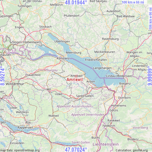
Amriswil GPS coordinates[2]
47° 32' 49.164" North, 9° 17' 45.096" East
| Map corner | latitude | longitude |
|---|---|---|
| Upper-left | 48.01944°, | 8.59274° |
| Center: | 47.54699°, | 9.29586° |
| Lower-right: | 47.07024°, | 9.99899° |
| Map W x H: | 105.5×105.5 km | = 65.6×65.6mi |
| max Lat: | 47.76737° ⇑5.3% North |
| Amriswil: | 47.54699° |
| min Lat: | ⇓94.7% South 45.83203° |
| min Long | Amriswil | max Long |
| 5.97153° | 9.29586° | 10.44624° |
| W 94.1%⇐ | ⇒5.9% E |
Elevation
Elevation of Amriswil is 451 m = 1480 ft, and this is 107.2 m = 352 ft below average elevation for this country.
| Max E: |
1845 m = 6053 ft | 62.2% |
| Avg. | 558.2 m = 1831 ft | |
| Amriswil | 451 m = 1480 ft | |
Min E: |
197 m = 646 ft | 37.8% |
See also: Switzerland elevation on elevation.city.
Geographical zone
Amriswil is located in North temperate zone (between Tropic of Cancer and the Arctic Circle). Distance of this North polar circle is 2114.4 km =1313.8 mi to North.| Distance of | km | miles | from Amriswil |
|---|---|---|---|
| North Pole | 4720.3 | 2933.1 | to North |
| Arctic Circle | 2114.4 | 1313.8 | to North |
| Tropic Cancer | 2680.8 | 1665.8 | to South |
| Equator | 5286.7 | 3285 | to South |


Nearby cities:
15 places around Amriswil: (largest is in red/bold)
• Altnau
7.5 km =4.7 mi,  340°
340°
• Egnach
6.4 km =4 mi,  94°
94°
• Erlen
4.6 km =2.9 mi,  271°
271°
• Güttingen
6.3 km =3.9 mi,  354°
354°
• Hohentannen
6.8 km =4.2 mi,  231°
231°
• Häggenschwil
6.9 km =4.3 mi,  147°
147°
• Kesswil
5.4 km =3.4 mi,  17°
17°
• Langrickenbach
6.3 km =3.9 mi,  324°
324°
• Muolen
3.6 km =2.2 mi,  143°
143°
• Roggwil
9.2 km =5.7 mi,  124°
124°
• Romanshorn
6.6 km =4.1 mi,  71°
71°
• Salmsach
5.8 km =3.6 mi,  81°
81°
• Sulgen
8.3 km =5.2 mi,  264°
264°
• Uttwil
5.4 km =3.4 mi,  39°
39°
• Waldkirch
8.7 km =5.4 mi,  184°
184°
Sources, notices
• [Note1] Compared only with cities in Switzerland existing in our database
• [Src1] Map data: © OpenStreetMap contributors (CC-BY-SA)
• [Src2] Other city data from geonames.org with taken over terms of usage.
• [Src3] Geographical zone / Annual Mean Temperature by Robert A. Rohde @ Wikipedia
