Kriegstetten geodata
Kriegstetten (Solothurn) is a populated place; located in Switzerland in Europe/Zurich (GMT+2) time zone. With population of 1,116 people, there are 1255 cities with bigger population in this country. Compared to other cities in Switzerland, 54.8% of cities are located further ↑North; 71.8% of cities are located further →East and 59.8% of cities have higher elevation than Kriegstetten. Note1


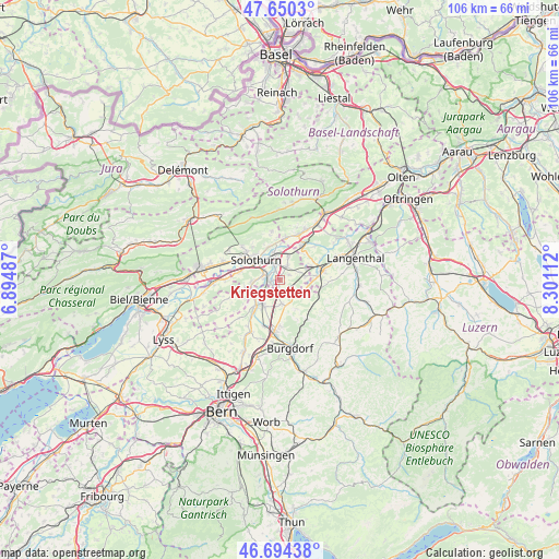
Kriegstetten GPS coordinates[2]
47° 10' 28.164" North, 7° 35' 52.764" East
| Map corner | latitude | longitude |
|---|---|---|
| Upper-left | 47.6503°, | 6.89487° |
| Center: | 47.17449°, | 7.59799° |
| Lower-right: | 46.69438°, | 8.30112° |
| Map W x H: | 106.3×106.3 km | = 66.1×66.1mi |
| max Lat: | 47.76737° ⇑54.8% North |
| Kriegstetten: | 47.17449° |
| min Lat: | ⇓45.2% South 45.83203° |
| min Long | Kriegstetten | max Long |
| 5.97153° | 7.59799° | 10.44624° |
| W 28.2%⇐ | ⇒71.8% E |
Elevation
Elevation of Kriegstetten is 455 m = 1493 ft, and this is 103.2 m = 339 ft below average elevation for this country.
| Max E: |
1845 m = 6053 ft | 59.8% |
| Avg. | 558.2 m = 1831 ft | |
| Kriegstetten | 455 m = 1493 ft | |
Min E: |
197 m = 646 ft | 40.2% |
See also: Switzerland elevation on elevation.city.
Geographical zone
Kriegstetten is located in North temperate zone (between Tropic of Cancer and the Arctic Circle). Distance of this North polar circle is 2155.9 km =1339.6 mi to North.| Distance of | km | miles | from Kriegstetten |
|---|---|---|---|
| North Pole | 4761.8 | 2958.8 | to North |
| Arctic Circle | 2155.9 | 1339.6 | to North |
| Tropic Cancer | 2639.4 | 1640 | to South |
| Equator | 5245.3 | 3259.3 | to South |


Nearby cities:
15 places around Kriegstetten: (largest is in red/bold)
• Alchenstorf
6.2 km =3.9 mi,  152°
152°
• Biberist
2.8 km =1.7 mi,  283°
283°
• Bätterkinden
6.6 km =4.1 mi,  223°
223°
• Deitingen
4.8 km =3 mi,  19°
19°
• Derendingen
2.8 km =1.7 mi,  344°
344°
• Gerlafingen
2 km =1.2 mi,  258°
258°
• Koppigen
4.8 km =3 mi,  173°
173°
• Luterbach
4.5 km =2.8 mi,  347°
347°
• Oberönz
7.3 km =4.5 mi,  87°
87°
• Riedholz
6.7 km =4.2 mi, 340°
• Seeberg
5.5 km =3.4 mi,  112°
112°
• Solothurn
5.9 km =3.7 mi,  308°
308°
• Subingen
3.1 km =1.9 mi,  31°
31°
• Utzenstorf
5.8 km =3.6 mi, 215°
• Zuchwil
3.9 km =2.4 mi,  321°
321°
Sources, notices
• [Note1] Compared only with cities in Switzerland existing in our database
• [Src1] Map data: © OpenStreetMap contributors (CC-BY-SA)
• [Src2] Other city data from geonames.org with taken over terms of usage.
• [Src3] Geographical zone / Annual Mean Temperature by Robert A. Rohde @ Wikipedia
