Subingen geodata
Subingen (Solothurn) is a populated place; located in Switzerland in Europe/Zurich (GMT+2) time zone. With population of 2,852 people, there are 615 cities with bigger population in this country. Compared to other cities in Switzerland, 52.9% of cities are located further ↑North; 71.1% of cities are located further →East and 67.9% of cities have higher elevation than Subingen. Note1


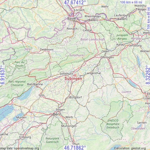
Subingen GPS coordinates[2]
47° 11' 54.672" North, 7° 37' 10.164" East
| Map corner | latitude | longitude |
|---|---|---|
| Upper-left | 47.67412°, | 6.91637° |
| Center: | 47.19852°, | 7.61949° |
| Lower-right: | 46.71862°, | 8.32262° |
| Map W x H: | 106.2×106.2 km | = 66×66mi |
| max Lat: | 47.76737° ⇑52.9% North |
| Subingen: | 47.19852° |
| min Lat: | ⇓47.1% South 45.83203° |
| min Long | Subingen | max Long |
| 5.97153° | 7.61949° | 10.44624° |
| W 28.9%⇐ | ⇒71.1% E |
Elevation
Elevation of Subingen is 441 m = 1447 ft, and this is 117.2 m = 385 ft below average elevation for this country.
| Max E: |
1845 m = 6053 ft | 67.9% |
| Avg. | 558.2 m = 1831 ft | |
| Subingen | 441 m = 1447 ft | |
Min E: |
197 m = 646 ft | 32.1% |
See also: Switzerland elevation on elevation.city.
Geographical zone
Subingen is located in North temperate zone (between Tropic of Cancer and the Arctic Circle). Distance of this North polar circle is 2153.2 km =1337.9 mi to North.| Distance of | km | miles | from Subingen |
|---|---|---|---|
| North Pole | 4759.1 | 2957.2 | to North |
| Arctic Circle | 2153.2 | 1337.9 | to North |
| Tropic Cancer | 2642.1 | 1641.7 | to South |
| Equator | 5248 | 3261 | to South |


Nearby cities:
15 places around Subingen: (largest is in red/bold)
• Attiswil
5.4 km =3.4 mi,  355°
355°
• Biberist
4.8 km =3 mi,  244°
244°
• Deitingen
1.8 km =1.1 mi, 358°
• Derendingen
2.3 km =1.4 mi,  269°
269°
• Gerlafingen
4.7 km =2.9 mi,  229°
229°
• Herzogenbuchsee
6.7 km =4.2 mi,  100°
100°
• Kriegstetten
3.1 km =1.9 mi,  211°
211°
• Luterbach
3.2 km =2 mi,  303°
303°
• Oberönz
6.1 km =3.8 mi,  111°
111°
• Riedholz
5.3 km =3.3 mi,  313°
313°
• Seeberg
5.9 km =3.7 mi,  143°
143°
• Solothurn
6.3 km =3.9 mi,  279°
279°
• Wangen an der Aare
4.5 km =2.8 mi,  33°
33°
• Wiedlisbach
6.3 km =3.9 mi,  18°
18°
• Zuchwil
4 km =2.5 mi, 275°
Sources, notices
• [Note1] Compared only with cities in Switzerland existing in our database
• [Src1] Map data: © OpenStreetMap contributors (CC-BY-SA)
• [Src2] Other city data from geonames.org with taken over terms of usage.
• [Src3] Geographical zone / Annual Mean Temperature by Robert A. Rohde @ Wikipedia
