Escholzmatt geodata
Escholzmatt (Lucerne) is a populated place; located in Switzerland in Europe/Zurich (GMT+2) time zone. With population of 3,192 people, there are 554 cities with bigger population in this country. Compared to other cities in Switzerland, 68.7% of cities are located further ↑North; 61.7% of cities are located further →East and 91.3% of cities have lower elevation than Escholzmatt. Note1
Administrative division(s):
- Level 1: Lucerne
- Level 2: Entlebuch District
- Level 3: Escholzmatt-Marbach


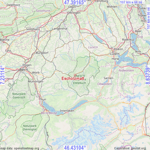
Escholzmatt GPS coordinates[2]
46° 54' 48.6" North, 7° 56' 3.336" East
| Map corner | latitude | longitude |
|---|---|---|
| Upper-left | 47.39165°, | 7.23114° |
| Center: | 46.9135°, | 7.93426° |
| Lower-right: | 46.43104°, | 8.63739° |
| Map W x H: | 106.8×106.8 km | = 66.4×66.4mi |
| max Lat: | 47.76737° ⇑68.7% North |
| Escholzmatt: | 46.9135° |
| min Lat: | ⇓31.3% South 45.83203° |
| min Long | Escholzmatt | max Long |
| 5.97153° | 7.93426° | 10.44624° |
| W 38.3%⇐ | ⇒61.7% E |
Elevation
Elevation of Escholzmatt is 856 m = 2808 ft, and this is 297.8 m = 977 ft above average elevation for this country.
| Max E: |
1845 m = 6053 ft | 8.7% |
| Escholzmatt | 856 m 2808 ft | |
| Avg. | 558.2 m = 1831 ft | |
Min E: |
197 m = 646 ft | 91.3% |
See also: Switzerland elevation on elevation.city.
Geographical zone
Escholzmatt is located in North temperate zone (between Tropic of Cancer and the Arctic Circle). Distance of this North polar circle is 2184.9 km =1357.6 mi to North.| Distance of | km | miles | from Escholzmatt |
|---|---|---|---|
| North Pole | 4790.8 | 2976.9 | to North |
| Arctic Circle | 2184.9 | 1357.6 | to North |
| Tropic Cancer | 2610.4 | 1622 | to South |
| Equator | 5216.3 | 3241.3 | to South |


Nearby cities:
15 places around Escholzmatt: (largest is in red/bold)
• Bowil
18.1 km =11.2 mi,  262°
262°
• Doppleschwand
14.8 km =9.2 mi,  38°
38°
• Eggiwil
11.3 km =7 mi,  248°
248°
• Entlebuch
13.4 km =8.3 mi,  47°
47°
• Flühli
7 km =4.3 mi,  118°
118°
• Hasle
11.5 km =7.1 mi, 51°
• Langnau
11.5 km =7.1 mi,  284°
284°
• Lauperswil
15.7 km =9.8 mi,  291°
291°
• Luthern
16.1 km =10 mi,  355°
355°
• Rüderswil
17.9 km =11.1 mi,  295°
295°
• Schangnau
11.1 km =6.9 mi,  210°
210°
• Schüpfheim
7.6 km =4.7 mi,  56°
56°
• Signau
16 km =9.9 mi,  272°
272°
• Trub
5.2 km =3.2 mi,  307°
307°
• Trubschachen
6.8 km =4.2 mi, 278°
Sources, notices
• [Note1] Compared only with cities in Switzerland existing in our database
• [Src1] Map data: © OpenStreetMap contributors (CC-BY-SA)
• [Src2] Other city data from geonames.org with taken over terms of usage.
• [Src3] Geographical zone / Annual Mean Temperature by Robert A. Rohde @ Wikipedia
