Nassian geodata
Nassian (Zanzan) is a seat of a third-order administrative division; located in Ivory Coast in Africa/Abidjan (GMT+0) time zone. In our database, there are 63 cities with bigger population. Compared to other cities in Ivory Coast, 80.3% of cities are located further ↓South; 89.7% of cities are located further ←West and 82.1% of cities have lower elevation than Nassian. Note1


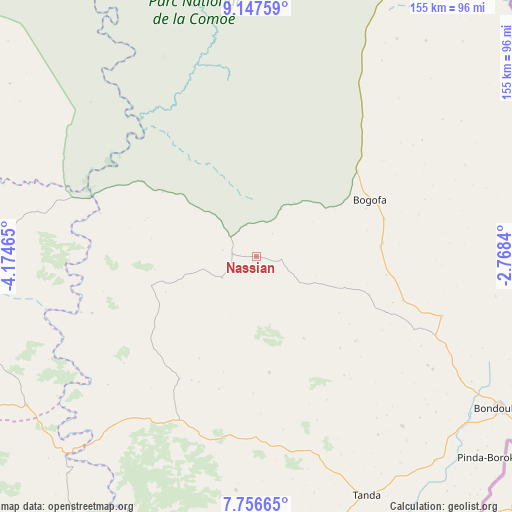
Nassian GPS coordinates[2]
8° 27' 9.9" North, 3° 28' 17.472" West
| Map corner | latitude | longitude |
|---|---|---|
| Upper-left | 9.14759°, | -4.17465° |
| Center: | 8.45275°, | -3.47152° |
| Lower-right: | 7.75665°, | -2.7684° |
| Map W x H: | 154.7×154.7 km | = 96.1×96.1mi |
| max Lat: | 10.48115° ⇑19.7% North |
| Nassian: | 8.45275° |
| min Lat: | ⇓80.3% South 4.42295° |
| min Long | Nassian | max Long |
| -8.42592° | -3.47152° | -2.80003° |
| W 89.7%⇐ | ⇒10.3% E |
Elevation
Elevation of Nassian is 353 m = 1158 ft, and this is 128.7 m = 422 ft above average elevation for this country.
| Max E: |
556 m = 1824 ft | 17.9% |
| Nassian | 353 m 1158 ft | |
| Avg. | 224.3 m = 736 ft | |
Min E: |
7 m = 23 ft | 82.1% |
See also: Ivory Coast elevation on elevation.city.
Geographical zone
Nassian is located in North Torrid zone (between Equator and Tropic of Cancer). Distance of Equator is 939.9 km =584 mi to South.| Distance of | km | miles | from Nassian |
|---|---|---|---|
| North Pole | 9067.2 | 5634.1 | to North |
| Arctic Circle | 6461.3 | 4014.9 | to North |
| Tropic Cancer | 1666.1 | 1035.3 | to North |
| Equator | 939.9 | 584 | to South |


Nearby cities:
15 places around Nassian: (largest is in red/bold)
• Agnibilékrou
149.9 km =93.1 mi,  168°
168°
• Bondoukou
87 km =54.1 mi,  121°
121°
• Bouna
104.8 km =65.1 mi,  29°
29°
• Dabakala
105.7 km =65.7 mi,  264°
264°
• Daoukro
164.2 km =102 mi,  199°
199°
• Katiola
182.7 km =113.5 mi, 258°
• Kong
147.1 km =91.4 mi,  301°
301°
• Kouassi-Kouassikro
181.4 km =112.7 mi,  227°
227°
• Koun-Fao
110 km =68.4 mi, 167°
• M’Bahiakro
146.3 km =90.9 mi,  220°
220°
• Prikro
106.6 km =66.2 mi,  212°
212°
• Sandégué
56.8 km =35.3 mi,  192°
192°
• Tanda
79.5 km =49.4 mi,  155°
155°
• Transua
112.3 km =69.8 mi,  153°
153°
• Téhini
129.8 km =80.7 mi,  350°
350°
Sources, notices
• [Note1] Compared only with cities in Ivory Coast existing in our database
• [Src1] Map data: © OpenStreetMap contributors (CC-BY-SA)
• [Src2] Other city data from geonames.org with taken over terms of usage.
• [Src3] Geographical zone / Annual Mean Temperature by Robert A. Rohde @ Wikipedia
