Tanda geodata
Tanda (Zanzan) is a seat of a third-order administrative division; located in Ivory Coast in Africa/Abidjan (GMT+0) time zone. With population of 20,161 people, there are 50 cities with bigger population in this country. Compared to other cities in Ivory Coast, 70.9% of cities are located further ↓South; 94.9% of cities are located further ←West and 66.7% of cities have lower elevation than Tanda. Note1


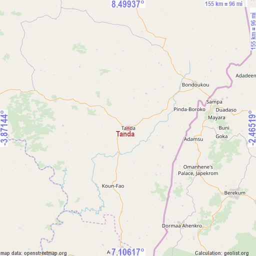
Tanda GPS coordinates[2]
7° 48' 12.06" North, 3° 10' 5.952" West
| Map corner | latitude | longitude |
|---|---|---|
| Upper-left | 8.49937°, | -3.87144° |
| Center: | 7.80335°, | -3.16832° |
| Lower-right: | 7.10617°, | -2.46519° |
| Map W x H: | 154.9×154.9 km | = 96.3×96.3mi |
| max Lat: | 10.48115° ⇑29.1% North |
| Tanda: | 7.80335° |
| min Lat: | ⇓70.9% South 4.42295° |
| min Long | Tanda | max Long |
| -8.42592° | -3.16832° | -2.80003° |
| W 94.9%⇐ | ⇒5.1% E |
Elevation
Elevation of Tanda is 274 m = 899 ft, and this is 49.7 m = 163 ft above average elevation for this country.
| Max E: |
556 m = 1824 ft | 33.3% |
| Tanda | 274 m 899 ft | |
| Avg. | 224.3 m = 736 ft | |
Min E: |
7 m = 23 ft | 66.7% |
See also: Ivory Coast elevation on elevation.city.
Geographical zone
Tanda is located in North Torrid zone (between Equator and Tropic of Cancer). Distance of Equator is 867.7 km =539.2 mi to South.| Distance of | km | miles | from Tanda |
|---|---|---|---|
| North Pole | 9139.4 | 5679 | to North |
| Arctic Circle | 6533.5 | 4059.7 | to North |
| Tropic Cancer | 1738.3 | 1080.1 | to North |
| Equator | 867.7 | 539.2 | to South |


Nearby cities:
15 places around Tanda: (largest is in red/bold)
• Abengourou
124.7 km =77.5 mi,  196°
196°
• Agnibilékrou
74.8 km =46.5 mi,  183°
183°
• Arrah
153.6 km =95.4 mi,  215°
215°
• Bocanda
168.3 km =104.6 mi,  240°
240°
• Bondoukou
48.4 km =30.1 mi,  57°
57°
• Bongouanou
171.6 km =106.6 mi, 221°
• Bouna
164.1 km =102 mi,  6°
6°
• Dabakala
152.1 km =94.5 mi,  294°
294°
• Daoukro
120.5 km =74.9 mi,  226°
226°
• Koun-Fao
36.3 km =22.6 mi,  194°
194°
• M’Bahiakro
134.7 km =83.7 mi,  253°
253°
• Nassian
79.5 km =49.4 mi,  335°
335°
• Prikro
92.9 km =57.7 mi,  259°
259°
• Sandégué
48.3 km =30 mi, 290°
• Transua
32.9 km =20.4 mi,  148°
148°
Sources, notices
• [Note1] Compared only with cities in Ivory Coast existing in our database
• [Src1] Map data: © OpenStreetMap contributors (CC-BY-SA)
• [Src2] Other city data from geonames.org with taken over terms of usage.
• [Src3] Geographical zone / Annual Mean Temperature by Robert A. Rohde @ Wikipedia
