Bouna geodata
Bouna (Zanzan) is a seat of a second-order administrative division; located in Ivory Coast in Africa/Abidjan (GMT+0) time zone. With population of 23,570 people, there are 46 cities with bigger population in this country. Compared to other cities in Ivory Coast, 86.3% of cities are located further ↓South; 99.1% of cities are located further ←West and 70.9% of cities have lower elevation than Bouna. Note1


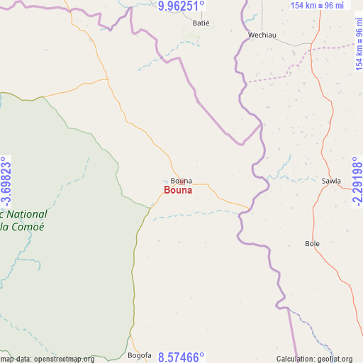
Bouna GPS coordinates[2]
9° 16' 9.372" North, 2° 59' 42.36" West
| Map corner | latitude | longitude |
|---|---|---|
| Upper-left | 9.96251°, | -3.69823° |
| Center: | 9.26927°, | -2.9951° |
| Lower-right: | 8.57466°, | -2.29198° |
| Map W x H: | 154.3×154.3 km | = 95.9×95.9mi |
| max Lat: | 10.48115° ⇑13.7% North |
| Bouna: | 9.26927° |
| min Lat: | ⇓86.3% South 4.42295° |
| min Long | Bouna | max Long |
| -8.42592° | -2.9951° | -2.80003° |
| W 99.1%⇐ | ⇒0.90000000000001% E |
Elevation
Elevation of Bouna is 318 m = 1043 ft, and this is 93.7 m = 307 ft above average elevation for this country.
| Max E: |
556 m = 1824 ft | 29.1% |
| Bouna | 318 m 1043 ft | |
| Avg. | 224.3 m = 736 ft | |
Min E: |
7 m = 23 ft | 70.9% |
See also: Ivory Coast elevation on elevation.city.
Geographical zone
Bouna is located in North Torrid zone (between Equator and Tropic of Cancer). Distance of Equator is 1030.6 km =640.4 mi to South.| Distance of | km | miles | from Bouna |
|---|---|---|---|
| North Pole | 8976.4 | 5577.7 | to North |
| Arctic Circle | 6370.5 | 3958.4 | to North |
| Tropic Cancer | 1575.3 | 978.8 | to North |
| Equator | 1030.6 | 640.4 | to South |


Nearby cities:
15 places around Bouna: (largest is in red/bold)
• Agnibilékrou
238.8 km =148.4 mi,  185°
185°
• Bondoukou
138.3 km =85.9 mi,  171°
171°
• Dabakala
187 km =116.2 mi,  237°
237°
• Ferkessédougou
243.9 km =151.6 mi,  278°
278°
• Kong
177.7 km =110.4 mi,  265°
265°
• Koun-Fao
200.1 km =124.3 mi, 188°
• M’Bahiakro
250 km =155.3 mi,  216°
216°
• Nassian
104.8 km =65.1 mi,  209°
209°
• Niakaramandougou
261.2 km =162.3 mi,  254°
254°
• Ouangolodougou
248.6 km =154.5 mi,  288°
288°
• Prikro
211.3 km =131.3 mi, 211°
• Sandégué
159.8 km =99.3 mi,  203°
203°
• Tanda
164.1 km =102 mi, 186°
• Transua
191.2 km =118.8 mi,  180°
180°
• Téhini
81.8 km =50.8 mi,  297°
297°
Sources, notices
• [Note1] Compared only with cities in Ivory Coast existing in our database
• [Src1] Map data: © OpenStreetMap contributors (CC-BY-SA)
• [Src2] Other city data from geonames.org with taken over terms of usage.
• [Src3] Geographical zone / Annual Mean Temperature by Robert A. Rohde @ Wikipedia
