Koun-Fao geodata
Koun-Fao (Zanzan) is a seat of a third-order administrative division; located in Ivory Coast in Africa/Abidjan (GMT+0) time zone. In our database, there are 63 cities with bigger population. Compared to other cities in Ivory Coast, 65% of cities are located further ↓South; 92.3% of cities are located further ←West and 59.8% of cities have higher elevation than Koun-Fao. Note1


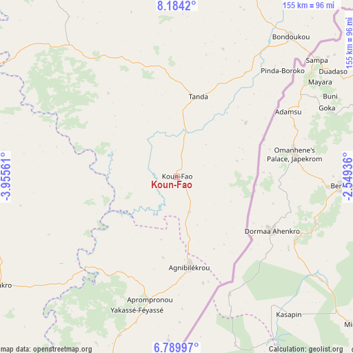
Koun-Fao GPS coordinates[2]
7° 29' 15.504" North, 3° 15' 8.964" West
| Map corner | latitude | longitude |
|---|---|---|
| Upper-left | 8.1842°, | -3.95561° |
| Center: | 7.48764°, | -3.25249° |
| Lower-right: | 6.78997°, | -2.54936° |
| Map W x H: | 155×155 km | = 96.3×96.3mi |
| max Lat: | 10.48115° ⇑35% North |
| Koun-Fao: | 7.48764° |
| min Lat: | ⇓65% South 4.42295° |
| min Long | Koun-Fao | max Long |
| -8.42592° | -3.25249° | -2.80003° |
| W 92.3%⇐ | ⇒7.7% E |
Elevation
Elevation of Koun-Fao is 196 m = 643 ft, and this is 28.3 m = 93 ft below average elevation for this country.
| Max E: |
556 m = 1824 ft | 59.8% |
| Avg. | 224.3 m = 736 ft | |
| Koun-Fao | 196 m = 643 ft | |
Min E: |
7 m = 23 ft | 40.2% |
See also: Ivory Coast elevation on elevation.city.
Geographical zone
Koun-Fao is located in North Torrid zone (between Equator and Tropic of Cancer). Distance of Equator is 832.5 km =517.3 mi to South.| Distance of | km | miles | from Koun-Fao |
|---|---|---|---|
| North Pole | 9174.5 | 5700.8 | to North |
| Arctic Circle | 6568.6 | 4081.5 | to North |
| Tropic Cancer | 1773.4 | 1101.9 | to North |
| Equator | 832.5 | 517.3 | to South |


Nearby cities:
15 places around Koun-Fao: (largest is in red/bold)
• Abengourou
88.5 km =55 mi,  197°
197°
• Affery
151 km =93.8 mi,  210°
210°
• Agnibilékrou
40 km =24.9 mi,  172°
172°
• Akoupé
141.3 km =87.8 mi, 209°
• Arrah
120.2 km =74.7 mi,  221°
221°
• Bocanda
145.4 km =90.3 mi,  251°
251°
• Bondoukou
79.1 km =49.2 mi,  39°
39°
• Bongouanou
140.2 km =87.1 mi,  228°
228°
• Daoukro
91.7 km =57 mi,  238°
238°
• M’Bahiakro
119.9 km =74.5 mi,  268°
268°
• Nassian
110 km =68.4 mi,  347°
347°
• Prikro
83.9 km =52.1 mi,  282°
282°
• Sandégué
63.2 km =39.3 mi,  325°
325°
• Tanda
36.3 km =22.6 mi,  14°
14°
• Transua
27.2 km =16.9 mi,  75°
75°
Sources, notices
• [Note1] Compared only with cities in Ivory Coast existing in our database
• [Src1] Map data: © OpenStreetMap contributors (CC-BY-SA)
• [Src2] Other city data from geonames.org with taken over terms of usage.
• [Src3] Geographical zone / Annual Mean Temperature by Robert A. Rohde @ Wikipedia
