Agnibilékrou geodata
Agnibilékrou (Comoé) is a seat of a third-order administrative division; located in Ivory Coast in Africa/Abidjan (GMT+0) time zone. With population of 43,061 people, there are 29 cities with bigger population in this country. Compared to other cities in Ivory Coast, 55.6% of cities are located further ↓South; 94% of cities are located further ←West and 56.4% of cities have lower elevation than Agnibilékrou. Note1


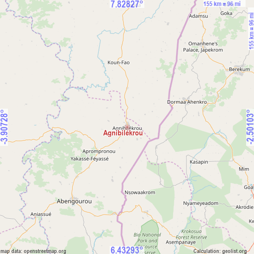
Agnibilékrou GPS coordinates[2]
7° 7' 52.068" North, 3° 12' 14.94" West
| Map corner | latitude | longitude |
|---|---|---|
| Upper-left | 7.82827°, | -3.90728° |
| Center: | 7.13113°, | -3.20415° |
| Lower-right: | 6.43293°, | -2.50103° |
| Map W x H: | 155.1×155.2 km | = 96.4×96.4mi |
| max Lat: | 10.48115° ⇑44.4% North |
| Agnibilékrou: | 7.13113° |
| min Lat: | ⇓55.6% South 4.42295° |
| min Long | Agnibilékrou | max Long |
| -8.42592° | -3.20415° | -2.80003° |
| W 94%⇐ | ⇒6% E |
Elevation
Elevation of Agnibilékrou is 236 m = 774 ft, and this is 11.7 m = 38 ft above average elevation for this country.
| Max E: |
556 m = 1824 ft | 43.6% |
| Agnibilékrou | 236 m 774 ft | |
| Avg. | 224.3 m = 736 ft | |
Min E: |
7 m = 23 ft | 56.4% |
See also: Agnibilékrou elevation on elevation.city.
Geographical zone
Agnibilékrou is located in North Torrid zone (between Equator and Tropic of Cancer). Distance of Equator is 792.9 km =492.7 mi to South.| Distance of | km | miles | from Agnibilékrou |
|---|---|---|---|
| North Pole | 9214.2 | 5725.4 | to North |
| Arctic Circle | 6608.3 | 4106.2 | to North |
| Tropic Cancer | 1813 | 1126.5 | to North |
| Equator | 792.9 | 492.7 | to South |


Nearby cities:
15 places around Agnibilékrou: (largest is in red/bold)
• Abengourou
55.1 km =34.2 mi,  215°
215°
• Affery
122.3 km =76 mi, 222°
• Akoupé
112.2 km =69.7 mi, 222°
• Arrah
98.6 km =61.3 mi,  238°
238°
• Bondoukou
110.5 km =68.7 mi,  23°
23°
• Bongouanou
122.6 km =76.2 mi, 244°
• Béttié
119.5 km =74.3 mi,  190°
190°
• Daoukro
84.1 km =52.3 mi,  264°
264°
• Koun-Fao
40 km =24.9 mi,  352°
352°
• M’Bahiakro
130.4 km =81 mi,  286°
286°
• Prikro
104.5 km =64.9 mi,  303°
303°
• Sandégué
100.4 km =62.4 mi,  335°
335°
• Tanda
74.8 km =46.5 mi,  3°
3°
• Transua
51.1 km =31.8 mi, 24°
• Yakassé-Attobrou
116.5 km =72.4 mi,  205°
205°
Sources, notices
• [Note1] Compared only with cities in Ivory Coast existing in our database
• [Src1] Map data: © OpenStreetMap contributors (CC-BY-SA)
• [Src2] Other city data from geonames.org with taken over terms of usage.
• [Src3] Geographical zone / Annual Mean Temperature by Robert A. Rohde @ Wikipedia
