Salamanca geodata
Salamanca (Coquimbo Region) is a populated place; located in Chile in America/Santiago (GMT-4) time zone. With population of 13,265 people, there are 103 cities with bigger population in this country. Compared to other cities in Chile, 84.8% of cities are located further ↓South; 71% of cities are located further ←West and 86.2% of cities have lower elevation than Salamanca. Note1
Administrative division(s):
- Level 1: Coquimbo Region
- Level 2: Provincia de Choapa
- Level 3: Salamanca


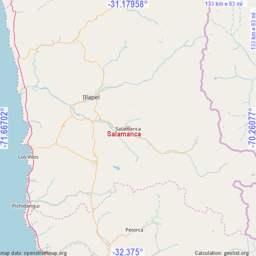
Salamanca GPS coordinates[2]
31° 46' 45.192" South, 70° 57' 50.004" West
| Map corner | latitude | longitude |
|---|---|---|
| Upper-left | -31.17958°, | -71.66702° |
| Center: | -31.77922°, | -70.96389° |
| Lower-right: | -32.375°, | -70.26077° |
| Map W x H: | 132.9×132.9 km | = 82.6×82.6mi |
| max Lat: | -18.19821° ⇑15.2% North |
| Salamanca: | -31.77922° |
| min Lat: | ⇓84.8% South -54.93355° |
| min Long | Salamanca | max Long |
| -109.42438° | -70.96389° | -67.60963° |
| W 71%⇐ | ⇒29% E |
Elevation
Elevation of Salamanca is 508 m = 1667 ft, and this is 235 m = 771 ft above average elevation for this country.
| Max E: |
3544 m = 11627 ft | 13.8% |
| Salamanca | 508 m 1667 ft | |
| Avg. | 273 m = 896 ft | |
Min E: |
1 m = 3 ft | 86.2% |
See also: Chile elevation on elevation.city.
Geographical zone
Salamanca is located in South temperate zone (between Tropic of Capricorn and the Antarctic Circle). Distance of this Southern Tropic circle is 927.6 km =576.4 mi to North.| Distance of | km | miles | from Salamanca |
|---|---|---|---|
| Equator | 3533.5 | 2195.6 | to North |
| Tropic Capricorn | 927.6 | 576.4 | to North |
| Antarctic Circle | 3867.7 | 2403.3 | to South |
| South Pole | 6473.5 | 4022.4 | to South |


Nearby cities:
15 places around Salamanca: (largest is in red/bold)
• Colina
160.8 km =99.9 mi,  170°
170°
• Hacienda La Calera
114.1 km =70.9 mi,  192°
192°
• Illapel
25.3 km =15.7 mi,  309°
309°
• La Ligua
79 km =49.1 mi,  198°
198°
• Limache
140.5 km =87.3 mi, 191°
• Llaillay
118 km =73.3 mi,  179°
179°
• Los Andes
122.2 km =75.9 mi,  163°
163°
• Monte Patria
120.6 km =74.9 mi,  0°
0°
• Ovalle
132.9 km =82.6 mi,  350°
350°
• Quillota
125.7 km =78.1 mi, 192°
• Quilpué
148 km =92 mi, 197°
• San Felipe
110.2 km =68.5 mi, 168°
• Valparaíso
153.1 km =95.1 mi, 204°
• Villa Alemana
145.6 km =90.5 mi, 195°
• Viña del Mar
149.1 km =92.6 mi, 201°
Sources, notices
• [Note1] Compared only with cities in Chile existing in our database
• [Src1] Map data: © OpenStreetMap contributors (CC-BY-SA)
• [Src2] Other city data from geonames.org with taken over terms of usage.
• [Src3] Geographical zone / Annual Mean Temperature by Robert A. Rohde @ Wikipedia
