Monte Patria geodata
Monte Patria (Coquimbo Region) is a populated place; located in Chile in America/Santiago (GMT-4) time zone. With population of 13,945 people, there are 98 cities with bigger population in this country. Compared to other cities in Chile, 86.2% of cities are located further ↓South; 71.7% of cities are located further ←West and 82.8% of cities have lower elevation than Monte Patria. Note1
Administrative division(s):
- Level 1: Coquimbo Region
- Level 2: Provincia de Limarí
- Level 3: Monte Patria


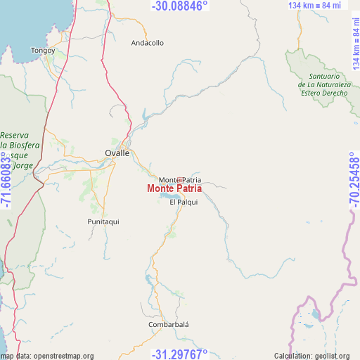
Monte Patria GPS coordinates[2]
30° 41' 41.856" South, 70° 57' 27.72" West
| Map corner | latitude | longitude |
|---|---|---|
| Upper-left | -30.08846°, | -71.66083° |
| Center: | -30.69496°, | -70.9577° |
| Lower-right: | -31.29767°, | -70.25458° |
| Map W x H: | 134.5×134.5 km | = 83.6×83.6mi |
| max Lat: | -18.19821° ⇑13.8% North |
| Monte Patria: | -30.69496° |
| min Lat: | ⇓86.2% South -54.93355° |
| min Long | Monte Patria | max Long |
| -109.42438° | -70.9577° | -67.60963° |
| W 71.7%⇐ | ⇒28.3% E |
Elevation
Elevation of Monte Patria is 429 m = 1407 ft, and this is 156 m = 512 ft above average elevation for this country.
| Max E: |
3544 m = 11627 ft | 17.2% |
| Monte Patria | 429 m 1407 ft | |
| Avg. | 273 m = 896 ft | |
Min E: |
1 m = 3 ft | 82.8% |
See also: Chile elevation on elevation.city.
Geographical zone
Monte Patria is located in South temperate zone (between Tropic of Capricorn and the Antarctic Circle). Distance of this Southern Tropic circle is 807 km =501.4 mi to North.| Distance of | km | miles | from Monte Patria |
|---|---|---|---|
| Equator | 3413 | 2120.7 | to North |
| Tropic Capricorn | 807 | 501.4 | to North |
| Antarctic Circle | 3988.2 | 2478.2 | to South |
| South Pole | 6594.1 | 4097.4 | to South |


Nearby cities:
15 places around Monte Patria: (largest is in red/bold)
• Coquimbo
90.2 km =56 mi,  336°
336°
• Hacienda La Calera
233.5 km =145.1 mi,  186°
186°
• Illapel
106.3 km =66.1 mi, 190°
• La Ligua
197.1 km =122.5 mi, 187°
• La Serena
92.2 km =57.3 mi, 342°
• Limache
259.8 km =161.4 mi, 186°
• Llaillay
238.6 km =148.3 mi,  179°
179°
• Los Andes
240.2 km =149.3 mi,  171°
171°
• Ovalle
25.3 km =15.7 mi,  294°
294°
• Quillota
244.9 km =152.2 mi, 186°
• Salamanca
120.6 km =74.9 mi, 180°
• San Felipe
229.5 km =142.6 mi, 174°
• Vallenar
236.4 km =146.9 mi,  4°
4°
• Vallenar
251.6 km =156.3 mi,  15°
15°
• Vicuña
77 km =47.8 mi, 17°
Sources, notices
• [Note1] Compared only with cities in Chile existing in our database
• [Src1] Map data: © OpenStreetMap contributors (CC-BY-SA)
• [Src2] Other city data from geonames.org with taken over terms of usage.
• [Src3] Geographical zone / Annual Mean Temperature by Robert A. Rohde @ Wikipedia
