Ovalle geodata
Ovalle (Coquimbo Region) is a seat of a second-order administrative division; located in Chile in America/Santiago (GMT-4) time zone. With population of 77,138 people, there are 31 cities with bigger population in this country. Compared to other cities in Chile, 86.9% of cities are located further ↓South; 66.2% of cities are located further ←West and 65.5% of cities have lower elevation than Ovalle. Note1


Ovalle GPS coordinates[2]
30° 36' 3.816" South, 71° 11' 56.436" West
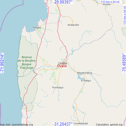
| Map corner | latitude | longitude |
|---|---|---|
| Upper-left | -29.99397°, | -71.90214° |
| Center: | -30.60106°, | -71.19901° |
| Lower-right: | -31.20437°, | -70.49589° |
| Map W x H: | 134.6×134.6 km | = 83.6×83.6mi |
| max Lat: | -18.19821° ⇑13.1% North |
| Ovalle: | -30.60106° |
| min Lat: | ⇓86.9% South -54.93355° |
| min Long | Ovalle | max Long |
| -109.42438° | -71.19901° | -67.60963° |
| W 66.2%⇐ | ⇒33.8% E |
Elevation
Elevation of Ovalle is 218 m = 715 ft, and this is 55 m = 180 ft below average elevation for this country.
| Max E: |
3544 m = 11627 ft | 34.5% |
| Avg. | 273 m = 896 ft | |
| Ovalle | 218 m = 715 ft | |
Min E: |
1 m = 3 ft | 65.5% |
See also: Ovalle elevation on elevation.city.
Geographical zone
Ovalle is located in South temperate zone (between Tropic of Capricorn and the Antarctic Circle). Distance of this Southern Tropic circle is 796.6 km =495 mi to North.| Distance of | km | miles | from Ovalle |
|---|---|---|---|
| Equator | 3402.5 | 2114.2 | to North |
| Tropic Capricorn | 796.6 | 495 | to North |
| Antarctic Circle | 3998.7 | 2484.7 | to South |
| South Pole | 6604.5 | 4103.8 | to South |


Nearby cities:
15 places around Ovalle: (largest is in red/bold)
• Coquimbo
73.3 km =45.5 mi,  349°
349°
• Hacienda La Calera
242.7 km =150.8 mi,  180°
180°
• Illapel
114.8 km =71.3 mi, 178°
• La Ligua
205.9 km =127.9 mi, 180°
• La Serena
77.6 km =48.2 mi,  356°
356°
• Limache
268.7 km =167 mi, 181°
• Llaillay
250.1 km =155.4 mi,  174°
174°
• Los Andes
254.7 km =158.3 mi, 167°
• Monte Patria
25.3 km =15.7 mi,  114°
114°
• Quillota
253.8 km =157.7 mi, 181°
• Salamanca
132.9 km =82.6 mi, 170°
• San Felipe
243.1 km =151.1 mi, 169°
• Vallenar
229.1 km =142.4 mi,  10°
10°
• Vallenar
249.2 km =154.8 mi,  21°
21°
• Vicuña
78.3 km =48.7 mi,  36°
36°
Sources, notices
• [Note1] Compared only with cities in Chile existing in our database
• [Src1] Map data: © OpenStreetMap contributors (CC-BY-SA)
• [Src2] Other city data from geonames.org with taken over terms of usage.
• [Src3] Geographical zone / Annual Mean Temperature by Robert A. Rohde @ Wikipedia
