Rancagua geodata
Rancagua (O'Higgins Region) is a seat of a first-order administrative division; located in Chile in America/Santiago (GMT-4) time zone. With population of 212,695 people, there are 10 cities with bigger population in this country. Compared to other cities in Chile, 62.8% of cities are located further ↓South; 77.2% of cities are located further ←West and 85.5% of cities have lower elevation than Rancagua. Note1
Administrative division(s):
- Level 1: O'Higgins Region
- Level 2: Provincia de Cachapoal
- Level 3: Rancagua


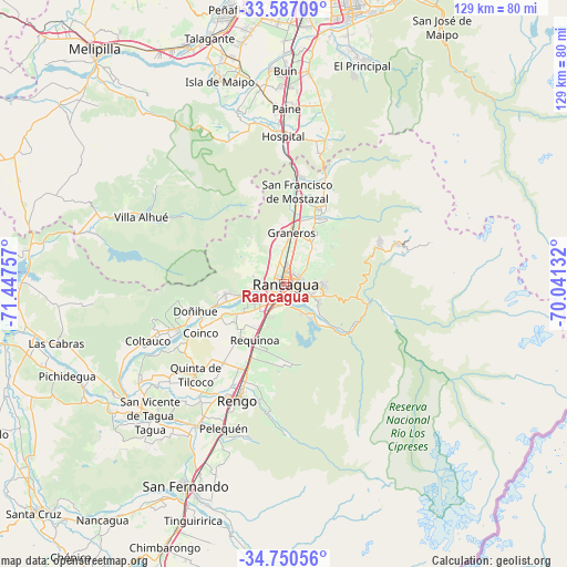
Rancagua GPS coordinates[2]
34° 10' 14.988" South, 70° 44' 39.984" West
| Map corner | latitude | longitude |
|---|---|---|
| Upper-left | -33.58709°, | -71.44757° |
| Center: | -34.17083°, | -70.74444° |
| Lower-right: | -34.75056°, | -70.04132° |
| Map W x H: | 129.4×129.4 km | = 80.4×80.4mi |
| max Lat: | -18.19821° ⇑37.2% North |
| Rancagua: | -34.17083° |
| min Lat: | ⇓62.8% South -54.93355° |
| min Long | Rancagua | max Long |
| -109.42438° | -70.74444° | -67.60963° |
| W 77.2%⇐ | ⇒22.8% E |
Elevation
Elevation of Rancagua is 506 m = 1660 ft, and this is 233 m = 764 ft above average elevation for this country.
| Max E: |
3544 m = 11627 ft | 14.5% |
| Rancagua | 506 m 1660 ft | |
| Avg. | 273 m = 896 ft | |
Min E: |
1 m = 3 ft | 85.5% |
See also: Rancagua elevation on elevation.city.
Geographical zone
Rancagua is located in South temperate zone (between Tropic of Capricorn and the Antarctic Circle). Distance of this Southern Tropic circle is 1193.5 km =741.6 mi to North.| Distance of | km | miles | from Rancagua |
|---|---|---|---|
| Equator | 3799.4 | 2360.8 | to North |
| Tropic Capricorn | 1193.5 | 741.6 | to North |
| Antarctic Circle | 3601.7 | 2238 | to South |
| South Pole | 6207.6 | 3857.2 | to South |


Nearby cities:
15 places around Rancagua: (largest is in red/bold)
• Buin
48.7 km =30.3 mi,  0°
0°
• Chimbarongo
66.2 km =41.1 mi,  204°
204°
• El Monte
58.9 km =36.6 mi,  337°
337°
• Graneros
11.5 km =7.1 mi,  7°
7°
• La Pintana
66.1 km =41.1 mi, 8°
• Machalí
8.8 km =5.5 mi,  97°
97°
• Melipilla
69 km =42.9 mi,  320°
320°
• Paine
40.3 km =25 mi, 0°
• Peñaflor
63.9 km =39.7 mi,  349°
349°
• Puente Alto
64.1 km =39.8 mi, 14°
• Rengo
28.2 km =17.5 mi, 201°
• San Bernardo
64.5 km =40.1 mi, 3°
• San Vicente
42.7 km =26.5 mi,  226°
226°
• San Vicente de Tagua Tagua
42.7 km =26.5 mi, 225°
• Talagante
58.8 km =36.5 mi, 343°
Sources, notices
• [Note1] Compared only with cities in Chile existing in our database
• [Src1] Map data: © OpenStreetMap contributors (CC-BY-SA)
• [Src2] Other city data from geonames.org with taken over terms of usage.
• [Src3] Geographical zone / Annual Mean Temperature by Robert A. Rohde @ Wikipedia
