Machalí geodata
Machalí (O'Higgins Region) is a populated place; located in Chile in America/Santiago (GMT-4) time zone. With population of 27,595 people, there are 62 cities with bigger population in this country. Compared to other cities in Chile, 62.1% of cities are located further ↓South; 84.1% of cities are located further ←West and 89% of cities have lower elevation than Machalí. Note1
Administrative division(s):
- Level 1: O'Higgins Region
- Level 2: Provincia de Cachapoal
- Level 3: Machali


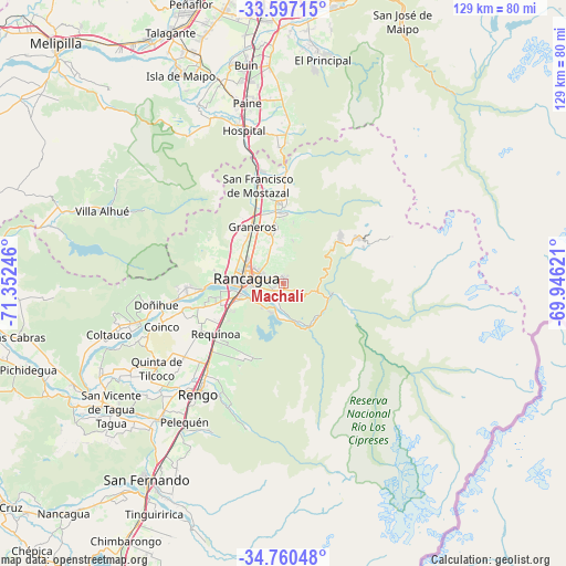
Machalí GPS coordinates[2]
34° 10' 50.952" South, 70° 38' 57.588" West
| Map corner | latitude | longitude |
|---|---|---|
| Upper-left | -33.59715°, | -71.35246° |
| Center: | -34.18082°, | -70.64933° |
| Lower-right: | -34.76048°, | -69.94621° |
| Map W x H: | 129.4×129.4 km | = 80.4×80.4mi |
| max Lat: | -18.19821° ⇑37.9% North |
| Machalí: | -34.18082° |
| min Lat: | ⇓62.1% South -54.93355° |
| min Long | Machalí | max Long |
| -109.42438° | -70.64933° | -67.60963° |
| W 84.1%⇐ | ⇒15.9% E |
Elevation
Elevation of Machalí is 568 m = 1864 ft, and this is 295 m = 968 ft above average elevation for this country.
| Max E: |
3544 m = 11627 ft | 11% |
| Machalí | 568 m 1864 ft | |
| Avg. | 273 m = 896 ft | |
Min E: |
1 m = 3 ft | 89% |
See also: Chile elevation on elevation.city.
Geographical zone
Machalí is located in South temperate zone (between Tropic of Capricorn and the Antarctic Circle). Distance of this Southern Tropic circle is 1194.6 km =742.3 mi to North.| Distance of | km | miles | from Machalí |
|---|---|---|---|
| Equator | 3800.6 | 2361.6 | to North |
| Tropic Capricorn | 1194.6 | 742.3 | to North |
| Antarctic Circle | 3600.6 | 2237.3 | to South |
| South Pole | 6206.5 | 3856.5 | to South |


Nearby cities:
15 places around Machalí: (largest is in red/bold)
• Buin
50.6 km =31.4 mi,  350°
350°
• Chimbarongo
69.3 km =43.1 mi,  211°
211°
• El Monte
63.7 km =39.6 mi,  330°
330°
• Graneros
14.4 km =8.9 mi, 330°
• La Pintana
66.5 km =41.3 mi,  1°
1°
• Melipilla
75.6 km =47 mi,  316°
316°
• Paine
42.3 km =26.3 mi, 348°
• Peñaflor
67.2 km =41.8 mi,  341°
341°
• Puente Alto
63.6 km =39.5 mi,  6°
6°
• Rancagua
8.8 km =5.5 mi,  277°
277°
• Rengo
31.6 km =19.6 mi,  217°
217°
• San Bernardo
65.6 km =40.8 mi,  355°
355°
• San Vicente
48.8 km =30.3 mi,  234°
234°
• San Vicente de Tagua Tagua
48.7 km =30.3 mi, 233°
• Talagante
62.9 km =39.1 mi, 335°
Sources, notices
• [Note1] Compared only with cities in Chile existing in our database
• [Src1] Map data: © OpenStreetMap contributors (CC-BY-SA)
• [Src2] Other city data from geonames.org with taken over terms of usage.
• [Src3] Geographical zone / Annual Mean Temperature by Robert A. Rohde @ Wikipedia
