San Vicente geodata
San Vicente (O'Higgins Region) is a populated place; located in Chile in America/Santiago (GMT-4) time zone. With population of 22,572 people, there are 74 cities with bigger population in this country. Compared to other cities in Chile, 60.7% of cities are located further ↓South; 68.3% of cities are located further ←West and 60.7% of cities have lower elevation than San Vicente. Note1
Administrative division(s):
- Level 1: O'Higgins Region
- Level 2: Provincia de Cachapoal
- Level 3: San Vicente


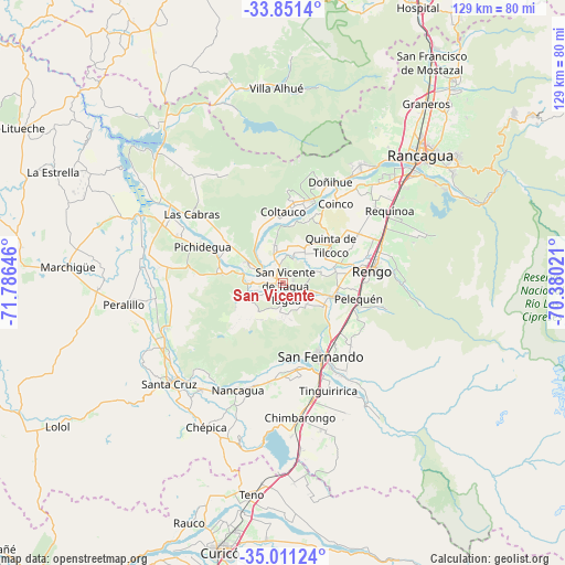
San Vicente GPS coordinates[2]
34° 25' 59.988" South, 71° 4' 59.988" West
| Map corner | latitude | longitude |
|---|---|---|
| Upper-left | -33.8514°, | -71.78646° |
| Center: | -34.43333°, | -71.08333° |
| Lower-right: | -35.01124°, | -70.38021° |
| Map W x H: | 129×129 km | = 80.2×80.2mi |
| max Lat: | -18.19821° ⇑39.3% North |
| San Vicente: | -34.43333° |
| min Lat: | ⇓60.7% South -54.93355° |
| min Long | San Vicente | max Long |
| -109.42438° | -71.08333° | -67.60963° |
| W 68.3%⇐ | ⇒31.7% E |
Elevation
Elevation of San Vicente is 210 m = 689 ft, and this is 63 m = 207 ft below average elevation for this country.
| Max E: |
3544 m = 11627 ft | 39.3% |
| Avg. | 273 m = 896 ft | |
| San Vicente | 210 m = 689 ft | |
Min E: |
1 m = 3 ft | 60.7% |
See also: Chile elevation on elevation.city.
Geographical zone
San Vicente is located in South temperate zone (between Tropic of Capricorn and the Antarctic Circle). Distance of this Southern Tropic circle is 1222.7 km =759.8 mi to North.| Distance of | km | miles | from San Vicente |
|---|---|---|---|
| Equator | 3828.6 | 2379 | to North |
| Tropic Capricorn | 1222.7 | 759.8 | to North |
| Antarctic Circle | 3572.5 | 2219.8 | to South |
| South Pole | 6178.4 | 3839.1 | to South |


Nearby cities:
15 places around San Vicente: (largest is in red/bold)
• Buin
84 km =52.2 mi,  21°
21°
• Chimbarongo
31.3 km =19.4 mi,  173°
173°
• Curicó
62.7 km =39 mi,  193°
193°
• El Monte
84.3 km =52.4 mi,  6°
6°
• Graneros
52.1 km =32.4 mi,  38°
38°
• Machalí
48.8 km =30.3 mi,  54°
54°
• Melipilla
83.6 km =51.9 mi,  351°
351°
• Molina
77.9 km =48.4 mi, 193°
• Paine
76.3 km =47.4 mi, 24°
• Rancagua
42.7 km =26.5 mi, 46°
• Rauco
58.8 km =36.5 mi,  201°
201°
• Rengo
20.9 km =13 mi,  81°
81°
• San Vicente de Tagua Tagua
0.8 km =0.5 mi,  137°
137°
• Santa Cruz
34.5 km =21.4 mi,  228°
228°
• Teno
49.1 km =30.5 mi, 188°
Sources, notices
• [Note1] Compared only with cities in Chile existing in our database
• [Src1] Map data: © OpenStreetMap contributors (CC-BY-SA)
• [Src2] Other city data from geonames.org with taken over terms of usage.
• [Src3] Geographical zone / Annual Mean Temperature by Robert A. Rohde @ Wikipedia
