Rengo geodata
Rengo (O'Higgins Region) is a populated place; located in Chile in America/Santiago (GMT-4) time zone. With population of 38,100 people, there are 47 cities with bigger population in this country. Compared to other cities in Chile, 61.4% of cities are located further ↓South; 75.9% of cities are located further ←West and 76.6% of cities have lower elevation than Rengo. Note1
Administrative division(s):
- Level 1: O'Higgins Region
- Level 2: Provincia de Cachapoal
- Level 3: Rengo


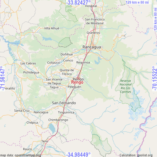
Rengo GPS coordinates[2]
34° 24' 23.004" South, 70° 51' 30.024" West
| Map corner | latitude | longitude |
|---|---|---|
| Upper-left | -33.82427°, | -71.56147° |
| Center: | -34.40639°, | -70.85834° |
| Lower-right: | -34.98449°, | -70.15522° |
| Map W x H: | 129×129 km | = 80.2×80.2mi |
| max Lat: | -18.19821° ⇑38.6% North |
| Rengo: | -34.40639° |
| min Lat: | ⇓61.4% South -54.93355° |
| min Long | Rengo | max Long |
| -109.42438° | -70.85834° | -67.60963° |
| W 75.9%⇐ | ⇒24.1% E |
Elevation
Elevation of Rengo is 326 m = 1070 ft, and this is 53 m = 174 ft above average elevation for this country.
| Max E: |
3544 m = 11627 ft | 23.4% |
| Rengo | 326 m 1070 ft | |
| Avg. | 273 m = 896 ft | |
Min E: |
1 m = 3 ft | 76.6% |
See also: Chile elevation on elevation.city.
Geographical zone
Rengo is located in South temperate zone (between Tropic of Capricorn and the Antarctic Circle). Distance of this Southern Tropic circle is 1219.7 km =757.9 mi to North.| Distance of | km | miles | from Rengo |
|---|---|---|---|
| Equator | 3825.6 | 2377.1 | to North |
| Tropic Capricorn | 1219.7 | 757.9 | to North |
| Antarctic Circle | 3575.5 | 2221.7 | to South |
| South Pole | 6181.4 | 3840.9 | to South |


Nearby cities:
15 places around Rengo: (largest is in red/bold)
• Buin
75.7 km =47 mi,  8°
8°
• Chimbarongo
38 km =23.6 mi,  206°
206°
• Curicó
72.9 km =45.3 mi, 208°
• El Monte
81.6 km =50.7 mi,  351°
351°
• Graneros
39.4 km =24.5 mi,  17°
17°
• Machalí
31.6 km =19.6 mi,  37°
37°
• Melipilla
86.3 km =53.6 mi,  337°
337°
• Paine
67.4 km =41.9 mi, 9°
• Rancagua
28.2 km =17.5 mi, 21°
• Rauco
71.4 km =44.4 mi,  216°
216°
• San Vicente
20.9 km =13 mi,  261°
261°
• San Vicente de Tagua Tagua
20.4 km =12.7 mi, 259°
• Santa Cruz
53.2 km =33.1 mi,  240°
240°
• Talagante
82.8 km =51.4 mi,  355°
355°
• Teno
58.6 km =36.4 mi, 208°
Sources, notices
• [Note1] Compared only with cities in Chile existing in our database
• [Src1] Map data: © OpenStreetMap contributors (CC-BY-SA)
• [Src2] Other city data from geonames.org with taken over terms of usage.
• [Src3] Geographical zone / Annual Mean Temperature by Robert A. Rohde @ Wikipedia
