Coyhaique geodata
Coyhaique (Aysén) is a seat of a first-order administrative division; located in Chile in America/Santiago (GMT-4) time zone. With population of 45,787 people, there are 44 cities with bigger population in this country. Compared to other cities in Chile, 95.2% of cities are located further ↑North; 55.9% of cities are located further →East and 73.8% of cities have lower elevation than Coyhaique. Note1


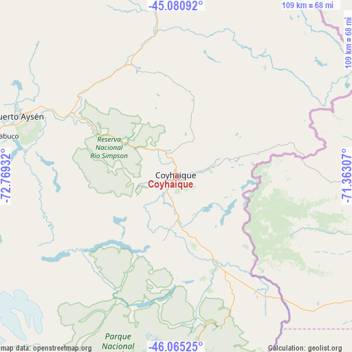
Coyhaique GPS coordinates[2]
45° 34' 30.864" South, 72° 3' 58.284" West
| Map corner | latitude | longitude |
|---|---|---|
| Upper-left | -45.08092°, | -72.76932° |
| Center: | -45.57524°, | -72.06619° |
| Lower-right: | -46.06525°, | -71.36307° |
| Map W x H: | 109.4×109.4 km | = 68×68mi |
| max Lat: | -18.19821° ⇑95.2% North |
| Coyhaique: | -45.57524° |
| min Lat: | ⇓4.8% South -54.93355° |
| min Long | Coyhaique | max Long |
| -109.42438° | -72.06619° | -67.60963° |
| W 44.1%⇐ | ⇒55.9% E |
Elevation
Elevation of Coyhaique is 299 m = 981 ft, and this is 26 m = 85 ft above average elevation for this country.
| Max E: |
3544 m = 11627 ft | 26.2% |
| Coyhaique | 299 m 981 ft | |
| Avg. | 273 m = 896 ft | |
Min E: |
1 m = 3 ft | 73.8% |
See also: Coyhaique elevation on elevation.city.
Geographical zone
Coyhaique is located in South temperate zone (between Tropic of Capricorn and the Antarctic Circle). Distance of this South polar circle is 2333.7 km =1450.1 mi to South.| Distance of | km | miles | from Coyhaique |
|---|---|---|---|
| Equator | 5067.5 | 3148.8 | to North |
| Tropic Capricorn | 2461.6 | 1529.6 | to North |
| Antarctic Circle | 2333.7 | 1450.1 | to South |
| South Pole | 4939.6 | 3069.3 | to South |


Nearby cities:
14 places around Coyhaique: (largest is in red/bold)
• Calbuco
431.3 km =268 mi,  348°
348°
• Castro
371 km =230.5 mi,  338°
338°
• Chaitén
300 km =186.4 mi, 350°
• Chile Chico
110.6 km =68.7 mi,  166°
166°
• Chonchi
355.4 km =220.8 mi, 337°
• Cochrane
190.8 km =118.6 mi,  191°
191°
• Dalcahue
377.3 km =234.4 mi, 340°
• Futaleufú
266.2 km =165.4 mi,  3°
3°
• La Junta
180 km =111.8 mi, 351°
• Palena
218.5 km =135.8 mi,  5°
5°
• Puerto Aysén
52.4 km =32.6 mi,  291°
291°
• Puerto Chacabuco
59.7 km =37.1 mi,  281°
281°
• Puerto Cisnes
104.5 km =64.9 mi,  331°
331°
• Quellón
299.7 km =186.2 mi, 335°
Sources, notices
• [Note1] Compared only with cities in Chile existing in our database
• [Src1] Map data: © OpenStreetMap contributors (CC-BY-SA)
• [Src2] Other city data from geonames.org with taken over terms of usage.
• [Src3] Geographical zone / Annual Mean Temperature by Robert A. Rohde @ Wikipedia
