Dalcahue geodata
Dalcahue (Los Lagos Region) is a populated place; located in Chile in America/Santiago (GMT-4) time zone. With population of 13,076 people, there are 104 cities with bigger population in this country. Compared to other cities in Chile, 87.6% of cities are located further ↑North; 96.6% of cities are located further →East and 88.3% of cities have higher elevation than Dalcahue. Note1
Administrative division(s):
- Level 1: Los Lagos Region
- Level 2: Provincia de Chiloé
- Level 3: Dalcahue


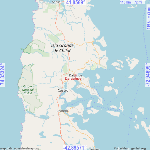
Dalcahue GPS coordinates[2]
42° 22' 42.42" South, 73° 39' 0.396" West
| Map corner | latitude | longitude |
|---|---|---|
| Upper-left | -41.8569°, | -74.35324° |
| Center: | -42.37845°, | -73.65011° |
| Lower-right: | -42.89571°, | -72.94699° |
| Map W x H: | 115.5×115.5 km | = 71.8×71.8mi |
| max Lat: | -18.19821° ⇑87.6% North |
| Dalcahue: | -42.37845° |
| min Lat: | ⇓12.4% South -54.93355° |
| min Long | Dalcahue | max Long |
| -109.42438° | -73.65011° | -67.60963° |
| W 3.4%⇐ | ⇒96.6% E |
Elevation
Elevation of Dalcahue is 19 m = 62 ft, and this is 254 m = 833 ft below average elevation for this country.
| Max E: |
3544 m = 11627 ft | 88.3% |
| Avg. | 273 m = 896 ft | |
| Dalcahue | 19 m = 62 ft | |
Min E: |
1 m = 3 ft | 11.7% |
See also: Chile elevation on elevation.city.
Geographical zone
Dalcahue is located in South temperate zone (between Tropic of Capricorn and the Antarctic Circle). Distance of this Southern Tropic circle is 2106.1 km =1308.7 mi to North.| Distance of | km | miles | from Dalcahue |
|---|---|---|---|
| Equator | 4712 | 2927.9 | to North |
| Tropic Capricorn | 2106.1 | 1308.7 | to North |
| Antarctic Circle | 2689.1 | 1670.9 | to South |
| South Pole | 5295 | 3290.2 | to South |


Nearby cities:
15 places around Dalcahue: (largest is in red/bold)
• Ancud
58.1 km =36.1 mi,  346°
346°
• Calbuco
79.8 km =49.6 mi,  32°
32°
• Castro
14.5 km =9 mi,  224°
224°
• Chaitén
97.6 km =60.6 mi,  127°
127°
• Chonchi
29.1 km =18.1 mi,  200°
200°
• Futaleufú
170.9 km =106.2 mi,  121°
121°
• La Ensenada
159.5 km =99.1 mi,  35°
35°
• La Junta
204.1 km =126.8 mi,  150°
150°
• Osorno
205.2 km =127.5 mi,  12°
12°
• Palena
203.8 km =126.6 mi, 132°
• Puerto Montt
116.8 km =72.6 mi, 30°
• Puerto Varas
130 km =80.8 mi, 25°
• Purranque
168 km =104.4 mi, 14°
• Puyehue
210.1 km =130.6 mi,  24°
24°
• Quellón
82.3 km =51.1 mi,  178°
178°
Sources, notices
• [Note1] Compared only with cities in Chile existing in our database
• [Src1] Map data: © OpenStreetMap contributors (CC-BY-SA)
• [Src2] Other city data from geonames.org with taken over terms of usage.
• [Src3] Geographical zone / Annual Mean Temperature by Robert A. Rohde @ Wikipedia
