Castro geodata
Castro (Los Lagos Region) is a populated place; located in Chile in America/Santiago (GMT-4) time zone. With population of 29,926 people, there are 57 cities with bigger population in this country. Compared to other cities in Chile, 88.3% of cities are located further ↑North; 97.9% of cities are located further →East and 62.8% of cities have higher elevation than Castro. Note1


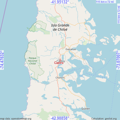
Castro GPS coordinates[2]
42° 28' 19.56" South, 73° 46' 23.484" West
| Map corner | latitude | longitude |
|---|---|---|
| Upper-left | -41.95132°, | -74.47632° |
| Center: | -42.4721°, | -73.77319° |
| Lower-right: | -42.98858°, | -73.07007° |
| Map W x H: | 115.3×115.3 km | = 71.6×71.6mi |
| max Lat: | -18.19821° ⇑88.3% North |
| Castro: | -42.4721° |
| min Lat: | ⇓11.7% South -54.93355° |
| min Long | Castro | max Long |
| -109.42438° | -73.77319° | -67.60963° |
| W 2.1%⇐ | ⇒97.9% E |
Elevation
Elevation of Castro is 81 m = 266 ft, and this is 192 m = 630 ft below average elevation for this country.
| Max E: |
3544 m = 11627 ft | 62.8% |
| Avg. | 273 m = 896 ft | |
| Castro | 81 m = 266 ft | |
Min E: |
1 m = 3 ft | 37.2% |
See also: Chile elevation on elevation.city.
Geographical zone
Castro is located in South temperate zone (between Tropic of Capricorn and the Antarctic Circle). Distance of this Southern Tropic circle is 2116.5 km =1315.1 mi to North.| Distance of | km | miles | from Castro |
|---|---|---|---|
| Equator | 4722.5 | 2934.4 | to North |
| Tropic Capricorn | 2116.5 | 1315.1 | to North |
| Antarctic Circle | 2678.7 | 1664.5 | to South |
| South Pole | 5284.6 | 3283.7 | to South |


Nearby cities:
15 places around Castro: (largest is in red/bold)
• Ancud
67 km =41.6 mi,  356°
356°
• Calbuco
94 km =58.4 mi,  34°
34°
• Chaitén
100.2 km =62.3 mi,  119°
119°
• Chonchi
16.9 km =10.5 mi,  180°
180°
• Dalcahue
14.5 km =9 mi,  44°
44°
• Futaleufú
174.5 km =108.4 mi, 117°
• La Ensenada
173.9 km =108.1 mi, 36°
• La Junta
200.4 km =124.5 mi,  146°
146°
• Osorno
217.7 km =135.3 mi,  14°
14°
• Palena
204.6 km =127.1 mi,  128°
128°
• Puerto Montt
131 km =81.4 mi, 31°
• Puerto Varas
143.8 km =89.4 mi, 26°
• Purranque
180.7 km =112.3 mi,  16°
16°
• Puyehue
223.9 km =139.1 mi, 25°
• Quellón
73 km =45.4 mi,  169°
169°
Sources, notices
• [Note1] Compared only with cities in Chile existing in our database
• [Src1] Map data: © OpenStreetMap contributors (CC-BY-SA)
• [Src2] Other city data from geonames.org with taken over terms of usage.
• [Src3] Geographical zone / Annual Mean Temperature by Robert A. Rohde @ Wikipedia
