Chonchi geodata
Chonchi (Los Lagos Region) is a populated place; located in Chile in America/Santiago (GMT-4) time zone. With population of 12,572 people, there are 106 cities with bigger population in this country. Compared to other cities in Chile, 89% of cities are located further ↑North; 98.6% of cities are located further →East and 86.9% of cities have higher elevation than Chonchi. Note1


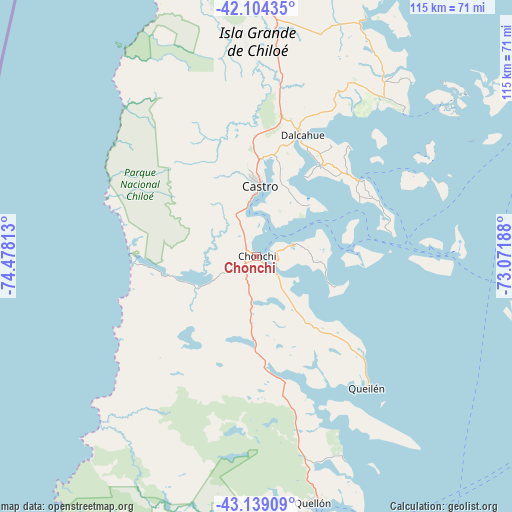
Chonchi GPS coordinates[2]
42° 37' 25.932" South, 73° 46' 30" West
| Map corner | latitude | longitude |
|---|---|---|
| Upper-left | -42.10435°, | -74.47813° |
| Center: | -42.62387°, | -73.775° |
| Lower-right: | -43.13909°, | -73.07188° |
| Map W x H: | 115.1×115.1 km | = 71.5×71.5mi |
| max Lat: | -18.19821° ⇑89% North |
| Chonchi: | -42.62387° |
| min Lat: | ⇓11% South -54.93355° |
| min Long | Chonchi | max Long |
| -109.42438° | -73.775° | -67.60963° |
| W 1.4%⇐ | ⇒98.6% E |
Elevation
Elevation of Chonchi is 20 m = 66 ft, and this is 253 m = 830 ft below average elevation for this country.
| Max E: |
3544 m = 11627 ft | 86.9% |
| Avg. | 273 m = 896 ft | |
| Chonchi | 20 m = 66 ft | |
Min E: |
1 m = 3 ft | 13.1% |
See also: Chile elevation on elevation.city.
Geographical zone
Chonchi is located in South temperate zone (between Tropic of Capricorn and the Antarctic Circle). Distance of this Southern Tropic circle is 2133.4 km =1325.6 mi to North.| Distance of | km | miles | from Chonchi |
|---|---|---|---|
| Equator | 4739.3 | 2944.9 | to North |
| Tropic Capricorn | 2133.4 | 1325.6 | to North |
| Antarctic Circle | 2661.8 | 1654 | to South |
| South Pole | 5267.7 | 3273.2 | to South |


Nearby cities:
15 places around Chonchi: (largest is in red/bold)
• Ancud
83.8 km =52.1 mi,  357°
357°
• Calbuco
108.4 km =67.4 mi,  29°
29°
• Castro
16.9 km =10.5 mi,  0°
0°
• Chaitén
93.1 km =57.8 mi,  110°
110°
• Dalcahue
29.1 km =18.1 mi,  20°
20°
• Futaleufú
167.4 km =104 mi, 111°
• La Ensenada
187.8 km =116.7 mi, 33°
• La Junta
186.6 km =115.9 mi,  143°
143°
• Osorno
234.1 km =145.5 mi,  13°
13°
• Palena
194.5 km =120.9 mi,  124°
124°
• Puerto Montt
145.6 km =90.5 mi, 28°
• Puerto Varas
159 km =98.8 mi, 24°
• Purranque
197 km =122.4 mi, 15°
• Puyehue
239.2 km =148.6 mi, 24°
• Quellón
56.5 km =35.1 mi,  166°
166°
Sources, notices
• [Note1] Compared only with cities in Chile existing in our database
• [Src1] Map data: © OpenStreetMap contributors (CC-BY-SA)
• [Src2] Other city data from geonames.org with taken over terms of usage.
• [Src3] Geographical zone / Annual Mean Temperature by Robert A. Rohde @ Wikipedia
