Calbuco geodata
Calbuco (Los Lagos Region) is a populated place; located in Chile in America/Santiago (GMT-4) time zone. With population of 12,490 people, there are 107 cities with bigger population in this country. Compared to other cities in Chile, 86.2% of cities are located further ↑North; 86.2% of cities are located further →East and 72.4% of cities have higher elevation than Calbuco. Note1


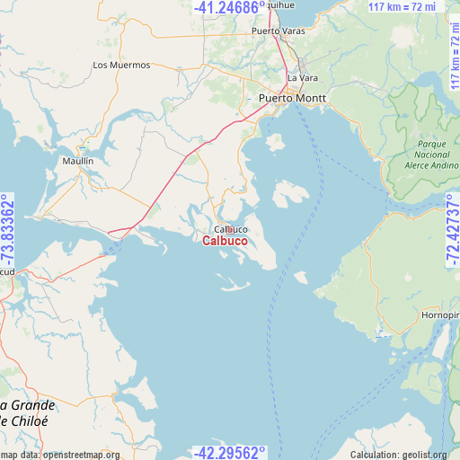
Calbuco GPS coordinates[2]
41° 46' 24.168" South, 73° 7' 49.764" West
| Map corner | latitude | longitude |
|---|---|---|
| Upper-left | -41.24686°, | -73.83362° |
| Center: | -41.77338°, | -73.13049° |
| Lower-right: | -42.29562°, | -72.42737° |
| Map W x H: | 116.6×116.6 km | = 72.5×72.5mi |
| max Lat: | -18.19821° ⇑86.2% North |
| Calbuco: | -41.77338° |
| min Lat: | ⇓13.8% South -54.93355° |
| min Long | Calbuco | max Long |
| -109.42438° | -73.13049° | -67.60963° |
| W 13.8%⇐ | ⇒86.2% E |
Elevation
Elevation of Calbuco is 38 m = 125 ft, and this is 235 m = 771 ft below average elevation for this country.
| Max E: |
3544 m = 11627 ft | 72.4% |
| Avg. | 273 m = 896 ft | |
| Calbuco | 38 m = 125 ft | |
Min E: |
1 m = 3 ft | 27.6% |
See also: Chile elevation on elevation.city.
Geographical zone
Calbuco is located in South temperate zone (between Tropic of Capricorn and the Antarctic Circle). Distance of this Southern Tropic circle is 2038.8 km =1266.9 mi to North.| Distance of | km | miles | from Calbuco |
|---|---|---|---|
| Equator | 4644.8 | 2886.1 | to North |
| Tropic Capricorn | 2038.8 | 1266.9 | to North |
| Antarctic Circle | 2756.4 | 1712.7 | to South |
| South Pole | 5362.3 | 3332 | to South |


Nearby cities:
15 places around Calbuco: (largest is in red/bold)
• Ancud
57.8 km =35.9 mi,  259°
259°
• Castro
94 km =58.4 mi,  214°
214°
• Chaitén
131.7 km =81.8 mi,  164°
164°
• Chonchi
108.4 km =67.4 mi, 209°
• Dalcahue
79.8 km =49.6 mi, 212°
• La Ensenada
79.9 km =49.6 mi,  38°
38°
• La Unión
164.6 km =102.3 mi,  1°
1°
• Osorno
133.4 km =82.9 mi,  359°
359°
• Puerto Montt
37.3 km =23.2 mi,  24°
24°
• Puerto Varas
51.9 km =32.2 mi,  13°
13°
• Purranque
95.7 km =59.5 mi, 358°
• Puyehue
131.5 km =81.7 mi, 19°
• Quellón
154.8 km =96.2 mi,  194°
194°
• Río Bueno
160.6 km =99.8 mi, 5°
• Santa Rosa
183.9 km =114.3 mi, 15°
Sources, notices
• [Note1] Compared only with cities in Chile existing in our database
• [Src1] Map data: © OpenStreetMap contributors (CC-BY-SA)
• [Src2] Other city data from geonames.org with taken over terms of usage.
• [Src3] Geographical zone / Annual Mean Temperature by Robert A. Rohde @ Wikipedia
