Palena geodata
Palena (Los Lagos Region) is a populated place; located in Chile in America/Santiago (GMT-4) time zone. With population of 1,690 people, there are 128 cities with bigger population in this country. Compared to other cities in Chile, 91.7% of cities are located further ↑North; 51.7% of cities are located further →East and 71% of cities have lower elevation than Palena. Note1


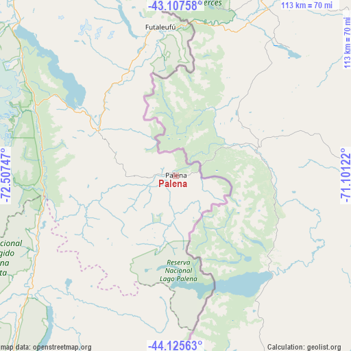
Palena GPS coordinates[2]
43° 37' 7.536" South, 71° 48' 15.624" West
| Map corner | latitude | longitude |
|---|---|---|
| Upper-left | -43.10758°, | -72.50747° |
| Center: | -43.61876°, | -71.80434° |
| Lower-right: | -44.12563°, | -71.10122° |
| Map W x H: | 113.2×113.2 km | = 70.3×70.3mi |
| max Lat: | -18.19821° ⇑91.7% North |
| Palena: | -43.61876° |
| min Lat: | ⇓8.3% South -54.93355° |
| min Long | Palena | max Long |
| -109.42438° | -71.80434° | -67.60963° |
| W 48.3%⇐ | ⇒51.7% E |
Elevation
Elevation of Palena is 262 m = 860 ft, and this is 11 m = 36 ft below average elevation for this country.
| Max E: |
3544 m = 11627 ft | 29% |
| Avg. | 273 m = 896 ft | |
| Palena | 262 m = 860 ft | |
Min E: |
1 m = 3 ft | 71% |
See also: Chile elevation on elevation.city.
Geographical zone
Palena is located in South temperate zone (between Tropic of Capricorn and the Antarctic Circle). Distance of this Southern Tropic circle is 2244 km =1394.4 mi to North.| Distance of | km | miles | from Palena |
|---|---|---|---|
| Equator | 4850 | 3013.6 | to North |
| Tropic Capricorn | 2244 | 1394.4 | to North |
| Antarctic Circle | 2551.2 | 1585.2 | to South |
| South Pole | 5157.1 | 3204.5 | to South |


Nearby cities:
15 places around Palena: (largest is in red/bold)
• Ancud
254.5 km =158.1 mi,  319°
319°
• Calbuco
232 km =144.2 mi,  332°
332°
• Castro
204.6 km =127.1 mi,  308°
308°
• Chaitén
107 km =66.5 mi, 316°
• Chonchi
194.5 km =120.9 mi,  304°
304°
• Coyhaique
218.5 km =135.8 mi,  185°
185°
• Dalcahue
203.8 km =126.6 mi, 312°
• Futaleufú
48.5 km =30.1 mi,  353°
353°
• La Junta
62.4 km =38.8 mi,  230°
230°
• Puerto Aysén
210.5 km =130.8 mi,  199°
199°
• Puerto Chacabuco
220.6 km =137.1 mi, 201°
• Puerto Cisnes
144.3 km =89.7 mi,  209°
209°
• Puerto Montt
256.5 km =159.4 mi,  338°
338°
• Puerto Varas
273.4 km =169.9 mi, 339°
• Quellón
156.7 km =97.4 mi,  290°
290°
Sources, notices
• [Note1] Compared only with cities in Chile existing in our database
• [Src1] Map data: © OpenStreetMap contributors (CC-BY-SA)
• [Src2] Other city data from geonames.org with taken over terms of usage.
• [Src3] Geographical zone / Annual Mean Temperature by Robert A. Rohde @ Wikipedia
