Nanga Eboko geodata
Nanga Eboko (Centre) is a populated place; located in Cameroon in Africa/Douala (GMT+1) time zone. With population of 29,909 people, there are 48 cities with bigger population in this country. Compared to other cities in Cameroon, 55.7% of cities are located further ↑North; 71.3% of cities are located further ←West and 50.8% of cities have higher elevation than Nanga Eboko. Note1


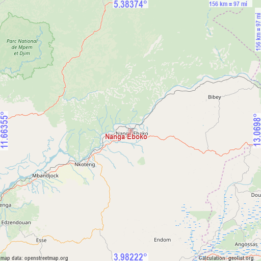
Nanga Eboko GPS coordinates[2]
4° 40' 59.988" North, 12° 22' 0.012" East
| Map corner | latitude | longitude |
|---|---|---|
| Upper-left | 5.38374°, | 11.66355° |
| Center: | 4.68333°, | 12.36667° |
| Lower-right: | 3.98222°, | 13.0698° |
| Map W x H: | 155.8×155.8 km | = 96.8×96.8mi |
| max Lat: | 12.57535° ⇑55.7% North |
| Nanga Eboko: | 4.68333° |
| min Lat: | ⇓44.3% South 2.35° |
| min Long | Nanga Eboko | max Long |
| 8.8724° | 12.36667° | 15.23288° |
| W 71.3%⇐ | ⇒28.7% E |
Elevation
Elevation of Nanga Eboko is 615 m = 2018 ft, and this is 58.9 m = 193 ft below average elevation for this country.
| Max E: |
1687 m = 5535 ft | 50.8% |
| Avg. | 673.9 m = 2211 ft | |
| Nanga Eboko | 615 m = 2018 ft | |
Min E: |
1 m = 3 ft | 49.2% |
See also: Cameroon elevation on elevation.city.
Geographical zone
Nanga Eboko is located in North Torrid zone (between Equator and Tropic of Cancer). Distance of Equator is 520.7 km =323.5 mi to South.| Distance of | km | miles | from Nanga Eboko |
|---|---|---|---|
| North Pole | 9486.3 | 5894.5 | to North |
| Arctic Circle | 6880.4 | 4275.3 | to North |
| Tropic Cancer | 2085.2 | 1295.7 | to North |
| Equator | 520.7 | 323.5 | to South |


Nearby cities:
15 places around Nanga Eboko: (largest is in red/bold)
• Abong Mbang
119.4 km =74.2 mi,  130°
130°
• Akonolinga
102.7 km =63.8 mi,  187°
187°
• Bélabo
107.1 km =66.5 mi,  74°
74°
• Essé
83 km =51.6 mi,  218°
218°
• Mbandjok
57.9 km =36 mi,  243°
243°
• Mbang
107.7 km =66.9 mi,  95°
95°
• Minta
49.3 km =30.6 mi, 103°
• Ngoro
112.9 km =70.2 mi,  285°
285°
• Nkoteng
41.3 km =25.7 mi, 243°
• Ntui
85.3 km =53 mi,  252°
252°
• Obala
108.8 km =67.6 mi, 238°
• Okoa
115.3 km =71.6 mi,  227°
227°
• Ombésa
124.1 km =77.1 mi,  265°
265°
• Saa
107.5 km =66.8 mi, 250°
• Yoko
94.7 km =58.8 mi,  356°
356°
Sources, notices
• [Note1] Compared only with cities in Cameroon existing in our database
• [Src1] Map data: © OpenStreetMap contributors (CC-BY-SA)
• [Src2] Other city data from geonames.org with taken over terms of usage.
• [Src3] Geographical zone / Annual Mean Temperature by Robert A. Rohde @ Wikipedia
