Mbang geodata
Mbang (East) is a populated place; located in Cameroon in Africa/Douala (GMT+1) time zone. With population of 1,237 people, there are 121 cities with bigger population in this country. Compared to other cities in Cameroon, 60.7% of cities are located further ↑North; 77% of cities are located further ←West and 59.8% of cities have lower elevation than Mbang. Note1


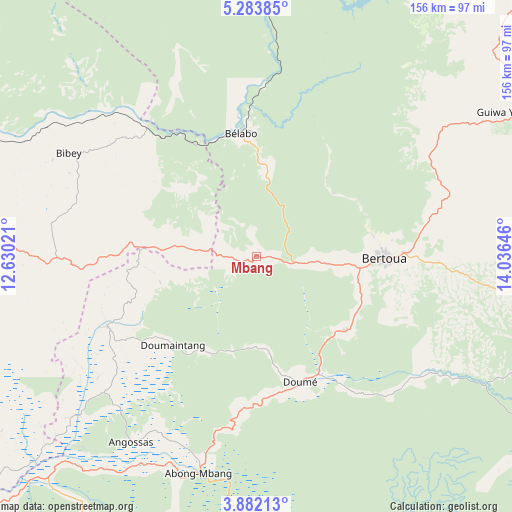
Mbang GPS coordinates[2]
4° 34' 59.988" North, 13° 19' 59.988" East
| Map corner | latitude | longitude |
|---|---|---|
| Upper-left | 5.28385°, | 12.63021° |
| Center: | 4.58333°, | 13.33333° |
| Lower-right: | 3.88213°, | 14.03646° |
| Map W x H: | 155.9×155.9 km | = 96.9×96.9mi |
| max Lat: | 12.57535° ⇑60.7% North |
| Mbang: | 4.58333° |
| min Lat: | ⇓39.3% South 2.35° |
| min Long | Mbang | max Long |
| 8.8724° | 13.33333° | 15.23288° |
| W 77%⇐ | ⇒23% E |
Elevation
Elevation of Mbang is 683 m = 2241 ft, and this is 9.1 m = 30 ft above average elevation for this country.
| Max E: |
1687 m = 5535 ft | 40.2% |
| Mbang | 683 m 2241 ft | |
| Avg. | 673.9 m = 2211 ft | |
Min E: |
1 m = 3 ft | 59.8% |
See also: Cameroon elevation on elevation.city.
Geographical zone
Mbang is located in North Torrid zone (between Equator and Tropic of Cancer). Distance of Equator is 509.6 km =316.7 mi to South.| Distance of | km | miles | from Mbang |
|---|---|---|---|
| North Pole | 9497.4 | 5901.4 | to North |
| Arctic Circle | 6891.6 | 4282.2 | to North |
| Tropic Cancer | 2096.3 | 1302.6 | to North |
| Equator | 509.6 | 316.7 | to South |


Nearby cities:
15 places around Mbang: (largest is in red/bold)
• Abong Mbang
68.8 km =42.8 mi,  193°
193°
• Akonolinga
150.6 km =93.6 mi,  232°
232°
• Batouri
115.7 km =71.9 mi,  98°
98°
• Bertoua
38.9 km =24.2 mi,  90°
90°
• Bélabo
39.1 km =24.3 mi,  354°
354°
• Bétaré Oya
140.3 km =87.2 mi,  36°
36°
• Dimako
34.1 km =21.2 mi,  130°
130°
• Doumé
41 km =25.5 mi,  161°
161°
• Essé
167.8 km =104.3 mi,  251°
251°
• Mbandjok
159.6 km =99.2 mi,  264°
264°
• Minta
59.1 km =36.7 mi,  270°
270°
• Nanga Eboko
107.7 km =66.9 mi,  275°
275°
• Ndelele
186.5 km =115.9 mi,  108°
108°
• Nkoteng
144.3 km =89.7 mi, 267°
• Yoko
154.4 km =95.9 mi,  313°
313°
Sources, notices
• [Note1] Compared only with cities in Cameroon existing in our database
• [Src1] Map data: © OpenStreetMap contributors (CC-BY-SA)
• [Src2] Other city data from geonames.org with taken over terms of usage.
• [Src3] Geographical zone / Annual Mean Temperature by Robert A. Rohde @ Wikipedia
