Bélabo geodata
Bélabo (East) is a populated place; located in Cameroon in Africa/Douala (GMT+1) time zone. With population of 22,553 people, there are 55 cities with bigger population in this country. Compared to other cities in Cameroon, 51.6% of cities are located further ↑North; 76.2% of cities are located further ←West and 51.6% of cities have higher elevation than Bélabo. Note1


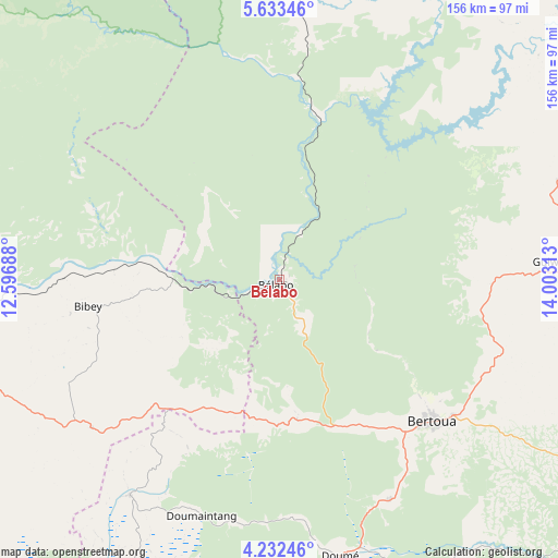
Bélabo GPS coordinates[2]
4° 55' 59.988" North, 13° 18' 0" East
| Map corner | latitude | longitude |
|---|---|---|
| Upper-left | 5.63346°, | 12.59688° |
| Center: | 4.93333°, | 13.3° |
| Lower-right: | 4.23246°, | 14.00313° |
| Map W x H: | 155.8×155.8 km | = 96.8×96.8mi |
| max Lat: | 12.57535° ⇑51.6% North |
| Bélabo: | 4.93333° |
| min Lat: | ⇓48.4% South 2.35° |
| min Long | Bélabo | max Long |
| 8.8724° | 13.3° | 15.23288° |
| W 76.2%⇐ | ⇒23.8% E |
Elevation
Elevation of Bélabo is 614 m = 2014 ft, and this is 59.9 m = 197 ft below average elevation for this country.
| Max E: |
1687 m = 5535 ft | 51.6% |
| Avg. | 673.9 m = 2211 ft | |
| Bélabo | 614 m = 2014 ft | |
Min E: |
1 m = 3 ft | 48.4% |
See also: Cameroon elevation on elevation.city.
Geographical zone
Bélabo is located in North Torrid zone (between Equator and Tropic of Cancer). Distance of Equator is 548.5 km =340.8 mi to South.| Distance of | km | miles | from Bélabo |
|---|---|---|---|
| North Pole | 9458.5 | 5877.2 | to North |
| Arctic Circle | 6852.6 | 4258 | to North |
| Tropic Cancer | 2057.4 | 1278.4 | to North |
| Equator | 548.5 | 340.8 | to South |


Nearby cities:
15 places around Bélabo: (largest is in red/bold)
• Abong Mbang
106.4 km =66.1 mi,  186°
186°
• Akonolinga
174.3 km =108.3 mi,  221°
221°
• Batouri
130.6 km =81.2 mi,  115°
115°
• Bertoua
58.2 km =36.2 mi,  132°
132°
• Bétaré Oya
114.1 km =70.9 mi,  49°
49°
• Dimako
67.9 km =42.2 mi,  154°
154°
• Doumé
79.6 km =49.5 mi,  167°
167°
• Essé
180.7 km =112.3 mi,  239°
239°
• Garoua Boulaï
174.1 km =108.2 mi, 52°
• Mbandjok
164.2 km =102 mi,  250°
250°
• Mbang
39.1 km =24.3 mi, 174°
• Minta
67.7 km =42.1 mi,  234°
234°
• Nanga Eboko
107.1 km =66.5 mi, 254°
• Nkoteng
147.8 km =91.8 mi, 251°
• Yoko
127.7 km =79.3 mi,  301°
301°
Sources, notices
• [Note1] Compared only with cities in Cameroon existing in our database
• [Src1] Map data: © OpenStreetMap contributors (CC-BY-SA)
• [Src2] Other city data from geonames.org with taken over terms of usage.
• [Src3] Geographical zone / Annual Mean Temperature by Robert A. Rohde @ Wikipedia
