Minta geodata
Minta (Centre) is a populated place; located in Cameroon in Africa/Douala (GMT+1) time zone. With population of 4,934 people, there are 104 cities with bigger population in this country. Compared to other cities in Cameroon, 60.7% of cities are located further ↑North; 73.8% of cities are located further ←West and 57.4% of cities have lower elevation than Minta. Note1


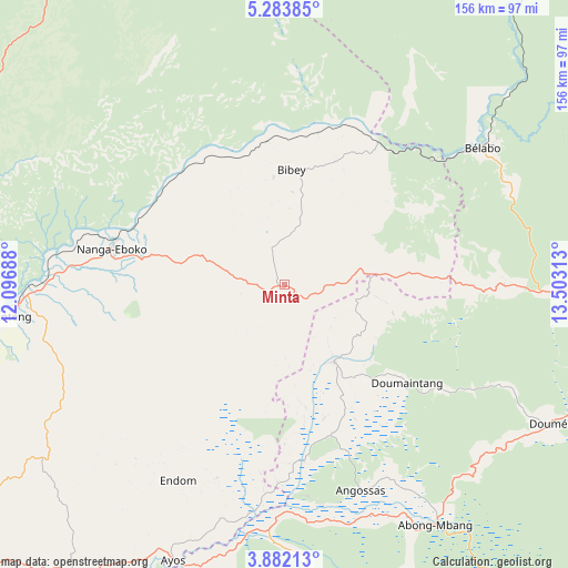
Minta GPS coordinates[2]
4° 34' 59.988" North, 12° 48' 0" East
| Map corner | latitude | longitude |
|---|---|---|
| Upper-left | 5.28385°, | 12.09688° |
| Center: | 4.58333°, | 12.8° |
| Lower-right: | 3.88213°, | 13.50313° |
| Map W x H: | 155.9×155.9 km | = 96.9×96.9mi |
| max Lat: | 12.57535° ⇑60.7% North |
| Minta: | 4.58333° |
| min Lat: | ⇓39.3% South 2.35° |
| min Long | Minta | max Long |
| 8.8724° | 12.8° | 15.23288° |
| W 73.8%⇐ | ⇒26.2% E |
Elevation
Elevation of Minta is 667 m = 2188 ft, and this is 6.9 m = 23 ft below average elevation for this country.
| Max E: |
1687 m = 5535 ft | 42.6% |
| Avg. | 673.9 m = 2211 ft | |
| Minta | 667 m = 2188 ft | |
Min E: |
1 m = 3 ft | 57.4% |
See also: Cameroon elevation on elevation.city.
Geographical zone
Minta is located in North Torrid zone (between Equator and Tropic of Cancer). Distance of Equator is 509.6 km =316.7 mi to South.| Distance of | km | miles | from Minta |
|---|---|---|---|
| North Pole | 9497.4 | 5901.4 | to North |
| Arctic Circle | 6891.6 | 4282.2 | to North |
| Tropic Cancer | 2096.3 | 1302.6 | to North |
| Equator | 509.6 | 316.7 | to South |


Nearby cities:
15 places around Minta: (largest is in red/bold)
• Abong Mbang
79.1 km =49.2 mi,  147°
147°
• Akonolinga
109.4 km =68 mi,  213°
213°
• Bertoua
98 km =60.9 mi,  90°
90°
• Bélabo
67.7 km =42.1 mi,  54°
54°
• Dimako
87.8 km =54.6 mi,  104°
104°
• Doumé
81.9 km =50.9 mi,  118°
118°
• Essé
113.3 km =70.4 mi,  241°
241°
• Mbandjok
100.9 km =62.7 mi,  261°
261°
• Mbang
59.1 km =36.7 mi, 90°
• Nanga Eboko
49.3 km =30.6 mi,  283°
283°
• Nkoteng
85.3 km =53 mi,  265°
265°
• Ntui
130.2 km =80.9 mi, 263°
• Obala
147.9 km =91.9 mi,  251°
251°
• Okoa
148.8 km =92.5 mi, 243°
• Yoko
118.4 km =73.6 mi,  333°
333°
Sources, notices
• [Note1] Compared only with cities in Cameroon existing in our database
• [Src1] Map data: © OpenStreetMap contributors (CC-BY-SA)
• [Src2] Other city data from geonames.org with taken over terms of usage.
• [Src3] Geographical zone / Annual Mean Temperature by Robert A. Rohde @ Wikipedia
