Abong Mbang geodata
Abong Mbang (East) is a populated place; located in Cameroon in Africa/Douala (GMT+1) time zone. With population of 14,661 people, there are 63 cities with bigger population in this country. Compared to other cities in Cameroon, 84.4% of cities are located further ↑North; 74.6% of cities are located further ←West and 60.7% of cities have lower elevation than Abong Mbang. Note1


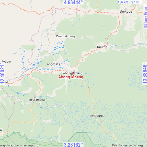
Abong Mbang GPS coordinates[2]
3° 58' 59.988" North, 13° 10' 59.988" East
| Map corner | latitude | longitude |
|---|---|---|
| Upper-left | 4.68444°, | 12.48021° |
| Center: | 3.98333°, | 13.18333° |
| Lower-right: | 3.28162°, | 13.88646° |
| Map W x H: | 156×156 km | = 96.9×96.9mi |
| max Lat: | 12.57535° ⇑84.4% North |
| Abong Mbang: | 3.98333° |
| min Lat: | ⇓15.6% South 2.35° |
| min Long | Abong Mbang | max Long |
| 8.8724° | 13.18333° | 15.23288° |
| W 74.6%⇐ | ⇒25.4% E |
Elevation
Elevation of Abong Mbang is 694 m = 2277 ft, and this is 20.1 m = 66 ft above average elevation for this country.
| Max E: |
1687 m = 5535 ft | 39.3% |
| Abong Mbang | 694 m 2277 ft | |
| Avg. | 673.9 m = 2211 ft | |
Min E: |
1 m = 3 ft | 60.7% |
See also: Cameroon elevation on elevation.city.
Geographical zone
Abong Mbang is located in North Torrid zone (between Equator and Tropic of Cancer). Distance of Equator is 442.9 km =275.2 mi to South.| Distance of | km | miles | from Abong Mbang |
|---|---|---|---|
| North Pole | 9564.2 | 5942.9 | to North |
| Arctic Circle | 6958.3 | 4323.7 | to North |
| Tropic Cancer | 2163 | 1344 | to North |
| Equator | 442.9 | 275.2 | to South |


Nearby cities:
15 places around Abong Mbang: (largest is in red/bold)
• Akonolinga
106.3 km =66.1 mi,  256°
256°
• Batouri
140.4 km =87.2 mi,  69°
69°
• Bertoua
86.3 km =53.6 mi,  40°
40°
• Bélabo
106.4 km =66.1 mi,  6°
6°
• Dimako
61.5 km =38.2 mi, 43°
• Doumé
40.6 km =25.2 mi,  46°
46°
• Essé
142.9 km =88.8 mi,  275°
275°
• Mbandjok
151.5 km =94.1 mi,  290°
290°
• Mbang
68.8 km =42.8 mi, 13°
• Minta
79.1 km =49.2 mi,  327°
327°
• Nanga Eboko
119.4 km =74.2 mi,  310°
310°
• Nkoteng
140.6 km =87.4 mi, 294°
• Ntui
179.5 km =111.5 mi, 286°
• Okoa
175.6 km =109.1 mi,  270°
270°
• Sangmélima
177.1 km =110 mi,  228°
228°
Sources, notices
• [Note1] Compared only with cities in Cameroon existing in our database
• [Src1] Map data: © OpenStreetMap contributors (CC-BY-SA)
• [Src2] Other city data from geonames.org with taken over terms of usage.
• [Src3] Geographical zone / Annual Mean Temperature by Robert A. Rohde @ Wikipedia
