Yoko geodata
Yoko (Centre) is a populated place; located in Cameroon in Africa/Douala (GMT+1) time zone. With population of 5,269 people, there are 101 cities with bigger population in this country. Compared to other cities in Cameroon, 63.9% of cities are located further ↓South; 70.5% of cities are located further ←West and 74.6% of cities have lower elevation than Yoko. Note1


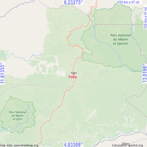
Yoko GPS coordinates[2]
5° 31' 59.988" North, 12° 19' 0.012" East
| Map corner | latitude | longitude |
|---|---|---|
| Upper-left | 6.23275°, | 11.61355° |
| Center: | 5.53333°, | 12.31667° |
| Lower-right: | 4.83308°, | 13.0198° |
| Map W x H: | 155.6×155.6 km | = 96.7×96.7mi |
| max Lat: | 12.57535° ⇑36.1% North |
| Yoko: | 5.53333° |
| min Lat: | ⇓63.9% South 2.35° |
| min Long | Yoko | max Long |
| 8.8724° | 12.31667° | 15.23288° |
| W 70.5%⇐ | ⇒29.5% E |
Elevation
Elevation of Yoko is 992 m = 3255 ft, and this is 318.1 m = 1044 ft above average elevation for this country.
| Max E: |
1687 m = 5535 ft | 25.4% |
| Yoko | 992 m 3255 ft | |
| Avg. | 673.9 m = 2211 ft | |
Min E: |
1 m = 3 ft | 74.6% |
See also: Cameroon elevation on elevation.city.
Geographical zone
Yoko is located in North Torrid zone (between Equator and Tropic of Cancer). Distance of Equator is 615.2 km =382.3 mi to South.| Distance of | km | miles | from Yoko |
|---|---|---|---|
| North Pole | 9391.8 | 5835.8 | to North |
| Arctic Circle | 6785.9 | 4216.6 | to North |
| Tropic Cancer | 1990.7 | 1237 | to North |
| Equator | 615.2 | 382.3 | to South |


Nearby cities:
15 places around Yoko: (largest is in red/bold)
• Bafia
148.3 km =92.1 mi,  234°
234°
• Bankim
109.9 km =68.3 mi,  303°
303°
• Banyo
146.1 km =90.8 mi,  337°
337°
• Bélabo
127.7 km =79.3 mi,  121°
121°
• Foumban
158.4 km =98.4 mi,  277°
277°
• Mbandjok
129 km =80.2 mi,  200°
200°
• Mbang
154.4 km =95.9 mi,  133°
133°
• Minta
118.4 km =73.6 mi,  153°
153°
• Nanga Eboko
94.7 km =58.8 mi,  176°
176°
• Ngoro
122 km =75.8 mi,  237°
237°
• Nkoteng
117.3 km =72.9 mi, 195°
• Ntui
142.3 km =88.4 mi,  212°
212°
• Ombésa
157.2 km =97.7 mi, 228°
• Somié
141.9 km =88.2 mi,  316°
316°
• Tibati
109.2 km =67.9 mi,  18°
18°
Sources, notices
• [Note1] Compared only with cities in Cameroon existing in our database
• [Src1] Map data: © OpenStreetMap contributors (CC-BY-SA)
• [Src2] Other city data from geonames.org with taken over terms of usage.
• [Src3] Geographical zone / Annual Mean Temperature by Robert A. Rohde @ Wikipedia
