Banyo geodata
Banyo (Adamaoua) is a populated place; located in Cameroon in Africa/Douala (GMT+1) time zone. With population of 40,798 people, there are 42 cities with bigger population in this country. Compared to other cities in Cameroon, 82% of cities are located further ↓South; 64.8% of cities are located further ←West and 77.9% of cities have lower elevation than Banyo. Note1


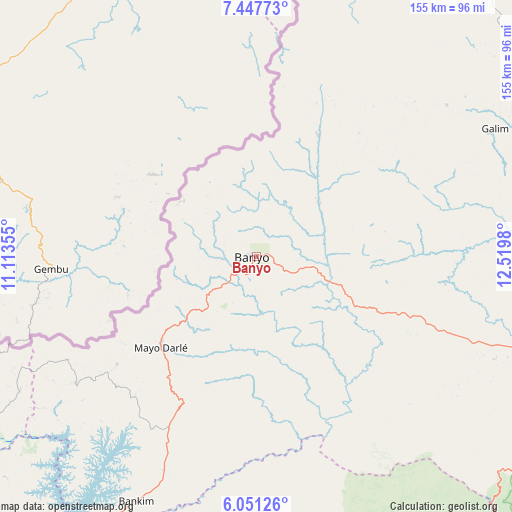
Banyo GPS coordinates[2]
6° 45' 0" North, 11° 49' 0.012" East
| Map corner | latitude | longitude |
|---|---|---|
| Upper-left | 7.44773°, | 11.11355° |
| Center: | 6.75°, | 11.81667° |
| Lower-right: | 6.05126°, | 12.5198° |
| Map W x H: | 155.3×155.3 km | = 96.5×96.5mi |
| max Lat: | 12.57535° ⇑18% North |
| Banyo: | 6.75° |
| min Lat: | ⇓82% South 2.35° |
| min Long | Banyo | max Long |
| 8.8724° | 11.81667° | 15.23288° |
| W 64.8%⇐ | ⇒35.2% E |
Elevation
Elevation of Banyo is 1077 m = 3533 ft, and this is 403.1 m = 1323 ft above average elevation for this country.
| Max E: |
1687 m = 5535 ft | 22.1% |
| Banyo | 1077 m 3533 ft | |
| Avg. | 673.9 m = 2211 ft | |
Min E: |
1 m = 3 ft | 77.9% |
See also: Banyo elevation on elevation.city.
Geographical zone
Banyo is located in North Torrid zone (between Equator and Tropic of Cancer). Distance of Equator is 750.5 km =466.3 mi to South.| Distance of | km | miles | from Banyo |
|---|---|---|---|
| North Pole | 9256.5 | 5751.7 | to North |
| Arctic Circle | 6650.6 | 4132.5 | to North |
| Tropic Cancer | 1855.4 | 1152.9 | to North |
| Equator | 750.5 | 466.3 | to South |


Nearby cities:
15 places around Banyo: (largest is in red/bold)
• Babanki
186.9 km =116.1 mi,  247°
247°
• Bankim
82.5 km =51.3 mi,  205°
205°
• Belo
186.2 km =115.7 mi, 248°
• Foumban
152.5 km =94.8 mi,  221°
221°
• Foumbot
190.3 km =118.2 mi, 223°
• Fundong
180 km =111.8 mi, 252°
• Jakiri
147.8 km =91.8 mi,  240°
240°
• Kontcha
142.9 km =88.8 mi,  18°
18°
• Kumbo
141 km =87.6 mi, 244°
• Mme-Bafumen
180.9 km =112.4 mi,  255°
255°
• Njinikom
178.9 km =111.2 mi, 251°
• Somié
53.4 km =33.2 mi,  232°
232°
• Tibati
95.1 km =59.1 mi,  109°
109°
• Tignère
114.7 km =71.3 mi,  53°
53°
• Yoko
146.1 km =90.8 mi,  157°
157°
Sources, notices
• [Note1] Compared only with cities in Cameroon existing in our database
• [Src1] Map data: © OpenStreetMap contributors (CC-BY-SA)
• [Src2] Other city data from geonames.org with taken over terms of usage.
• [Src3] Geographical zone / Annual Mean Temperature by Robert A. Rohde @ Wikipedia
